IMAGES TAKEN NEAR TO
Riding Hill, HALIFAX, HX3 7TS
Introduction
This page details the photographs taken nearby to Riding Hill, HX3 7TS by members of the Geograph project.
The Geograph project started in 2005 with the aim of publishing, organising and preserving representative images for every square kilometre of Great Britain, Ireland and the Isle of Man.

There are currently over 7.5m images from over14,400 individuals and you can help contribute to the project by visiting https://www.geograph.org.uk
Image Map
Images are licensed for reuse under creativecommons.org/licenses/by-sa/2.0
Notes
- Clicking on the map will re-center to the selected point.
- The higher the marker number, the further away the image location is from the centre of the postcode.
Image Listing (71 Images Found)
Images are licensed for reuse under creativecommons.org/licenses/by-sa/2.0
Image
Details
Distance
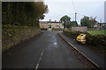
2
Footpath to Carr House Lane at Riding Hill, Shelf
You need a good pair of secateurs to use this path. Not having one with me I cannot say what the path was like round the corner.
Image: © Humphrey Bolton
Taken: 6 Sep 2020
0.07 miles
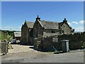
4
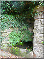
Spring and trough, Riding Hill, Shelf
Image: © Humphrey Bolton
Taken: 6 Sep 2020
0.09 miles
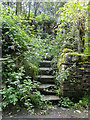
6
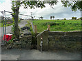
Stile on footpath to Carr House Road
You have to look carefully to find this stile. There is a sad stumo of the footpath signpost. Inside the old stone stile there is a newish wooden stile.
Image: © Humphrey Bolton
Taken: 6 Sep 2020
0.10 miles
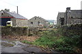
7

Green Lane, Shelf
A public footpath starts on the left just after the tree and site fence.
Image: © Humphrey Bolton
Taken: 6 Sep 2020
0.10 miles
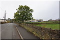
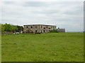
9
High Bentley Farm
A working cattle farm that includes this grade II* listed 17th century farmhouse (list entry 1133767).
Image: © Stephen Craven
Taken: 10 Jul 2022
0.12 miles
10
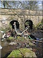
Riding Hill Bridge
Abandoned shopping trolley near the road bridge over Royds Hall Beck between Riding Hill and Manorley Lane. The beck forms part of the local authority boundary between Calderdale and Bradford.
Image: © Paul Glazzard
Taken: 1 Apr 2007
0.12 miles