IMAGES TAKEN NEAR TO
Lands Head Lane, HALIFAX, HX3 7SR
Introduction
This page details the photographs taken nearby to Lands Head Lane, HX3 7SR by members of the Geograph project.
The Geograph project started in 2005 with the aim of publishing, organising and preserving representative images for every square kilometre of Great Britain, Ireland and the Isle of Man.

There are currently over 7.5m images from over14,400 individuals and you can help contribute to the project by visiting https://www.geograph.org.uk
Image Map
Images are licensed for reuse under creativecommons.org/licenses/by-sa/2.0
Notes
- Clicking on the map will re-center to the selected point.
- The higher the marker number, the further away the image location is from the centre of the postcode.
Image Listing (29 Images Found)
Images are licensed for reuse under creativecommons.org/licenses/by-sa/2.0
Image
Details
Distance
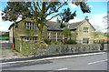
1
Barn Conversion at Marsh Hall
The two prominent roof line ventilators have been retained
Image: © Kevin Waterhouse
Taken: 23 Feb 2023
0.00 miles
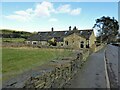
2
Marsh Hall, Northowram
This old house is listed. Grade II*. It is dated 1626, according to the listing.
Image: © Humphrey Bolton
Taken: 2 May 2016
0.01 miles


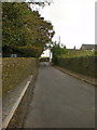
7
Junction of Cut Lane and Teal Lane, Northowram
The blue flowers on the left are forget-me-nots.
Image: © Humphrey Bolton
Taken: 2 May 2020
0.16 miles
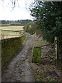
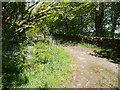
8

Junction of Teal Lane and Cut Lane
Image: © Alexander P Kapp
Taken: 12 Mar 2010
0.17 miles