IMAGES TAKEN NEAR TO
Soaper Lane, HALIFAX, HX3 7PS
Introduction
This page details the photographs taken nearby to Soaper Lane, HX3 7PS by members of the Geograph project.
The Geograph project started in 2005 with the aim of publishing, organising and preserving representative images for every square kilometre of Great Britain, Ireland and the Isle of Man.

There are currently over 7.5m images from over14,400 individuals and you can help contribute to the project by visiting https://www.geograph.org.uk
Image Map
Images are licensed for reuse under creativecommons.org/licenses/by-sa/2.0
Notes
- Clicking on the map will re-center to the selected point.
- The higher the marker number, the further away the image location is from the centre of the postcode.
Image Listing (59 Images Found)
Images are licensed for reuse under creativecommons.org/licenses/by-sa/2.0
Image
Details
Distance
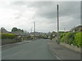
2
Soaper Lane - viewed from Shelf Moor
Image: © Betty Longbottom
Taken: 7 Jun 2009
0.07 miles
3
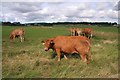
Cattle, Soaper Lane
Looking NW from Soaper Lane with houses of Lower Bracken Beds in the distance.
Image: © Mark Anderson
Taken: 2 Sep 2005
0.07 miles
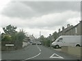
4

Burned Road - viewed from Burned Grove
Image: © Betty Longbottom
Taken: 7 Jun 2009
0.09 miles
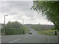
5
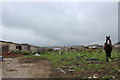
Paddock beside Windmill Farm, Shelf
This paddock caught my eye, due to the horrendous state it has been left in. It looked like a fly tipping site, with discarded black plastic bags particularly prevalent.
Image: © Chris Heaton
Taken: 29 Aug 2018
0.10 miles
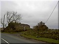
8
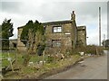
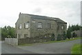
Windmill Farm, Burned Road, Shelf
There once was a windmill behind the farmhouse. A page on a local website http://www.an-englishmanshome.co.uk/a_story_about_shelf_windmill.htm says it was built in 1789, had sails of 60 feet length producing up to 36hp, and it was still extant (though disused) in the 1950s. Nothing remains of it now.
Image: © Stephen Craven
Taken: 12 Mar 2022
0.11 miles