IMAGES TAKEN NEAR TO
Hope Street, HALIFAX, HX3 7LG
Introduction
This page details the photographs taken nearby to Hope Street, HX3 7LG by members of the Geograph project.
The Geograph project started in 2005 with the aim of publishing, organising and preserving representative images for every square kilometre of Great Britain, Ireland and the Isle of Man.

There are currently over 7.5m images from over14,400 individuals and you can help contribute to the project by visiting https://www.geograph.org.uk
Image Map
Images are licensed for reuse under creativecommons.org/licenses/by-sa/2.0
Notes
- Clicking on the map will re-center to the selected point.
- The higher the marker number, the further away the image location is from the centre of the postcode.
Image Listing (73 Images Found)
Images are licensed for reuse under creativecommons.org/licenses/by-sa/2.0
Image
Details
Distance
1

Clough Mill, Shelf
This was a fine former textile mill complex with a multistorey block with internal engine house and an adjoining shed with a corner tower. This shows the base of the stone chimney behind the boiler house with at least one adjoining engine house. This mill was latterly used by the automotive products company Decosol but was demolished following a fire in 2005 and only the chimney remains. I photographed it from several angles but can no longer work out the view directions. The identification of this site took me well over half an hour using internet and book sources.
Image: © Chris Allen
Taken: 30 Jan 1994
0.02 miles
2
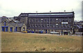
Clough Mill, Shelf
This was a fine former textile mill complex with multistorey block with internal engine house and an adjoining shed with a corner tower. This shows the multistorey block with the boiler house and at least one engine house to the left. This mill was latterly used by the automotive products company Decosol but was demolished following a fire in 2005 and only the chimney now remains. I photographed it from several angles but can no longer work out the view directions. The identification of this site took me well over half an hour using internet and book sources.
Image: © Chris Allen
Taken: 30 Jan 1994
0.02 miles
3
Clough Mill, Shelf
This was a fine textile mill complex with a multistorey block with internal engine house and an adjoining shed with a corner tower. This shows the multistorey block and the two tall arched windows nearest the photographer show the internal engine house that was probably for a double beam engine. This was latterly used by the automotive products company Decosol but was demolished following a fire in 2005 and only the chimney now remains as it carries antennae. I photographed the site from several angles but can nol onger identify the view directions. The identification of this site took me well over half an hour using internet and book sources.
Image: © Chris Allen
Taken: 30 Jan 1994
0.02 miles
4
Clough Mill, Shelf
This was a fine textile mill complex with a multistorey block with internal engine house and an adjoining shed with a corner tower. This shows the base of the stone chimney with at least one adjoining engine house. This mill was latterly used by the automotive products company Decosol but was demolished following a fire in 2005 and only the chimney now remains as it carries antennae. I photographed the site from several angles but now cannot decide on view directions. The identification of this site took me well over half an hour using internet and book sources.
Image: © Chris Allen
Taken: 30 Jan 1994
0.02 miles
5
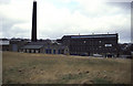
Clough Mill, Shelf
Now demolished following a fire. When photographed was being used by Decosol. The chimney later gained the obligatory antennae and may still be standing because of that.
Image: © Chris Allen
Taken: 30 Jan 1994
0.02 miles
6
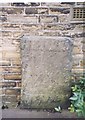
Old Guide Stone by the A644, Brighouse and Denholme Gate Road, Stonechair
By the A644, in parish of Halifax (Calderdale District), Brighouse and Denholme Gate Road, Stonechair, opposite Duke of York PH, attached to house wall on corner of West Street, behind the 'Stone chair'.
Inscription reads:-
(illegible)
1737
Grade II listed together with the 'Stone chair'.
List Entry Number: 1133800 https://historicengland.org.uk/listing/the-list/list-entry/1133800
Surveyed
Milestone Society National ID: YW_XSTCHa
Image: © Milestone Society
Taken: Unknown
0.03 miles
7
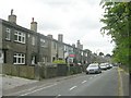
Cross Lane - Brighouse & Denholme Gate Road
Image: © Betty Longbottom
Taken: 7 Jun 2009
0.04 miles
8
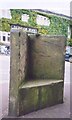
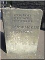
Old Guide stone/Stonechair, West St
Corner with Brighouse & Denholme Gate Road, opposite Duke of York Pub. Located on the South side of West St. Carved stone post, 18th century. Alternative views see https://www.geograph.org.uk/photo/4799995 & https://www.geograph.org.uk/photo/613840
Inscription reads: Halifax (finger) / (finger) Bradford // (finger) Deanhouse Gate / Brighouse (finger)
Grade II listed by Historic England. see https://historicengland.org.uk/listing/the-list/list-entry/1133800
Milestone Society National ID: YW_XSTCHb
Image: © Christine Minto
Taken: 21 Dec 2005
0.04 miles
9
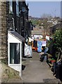
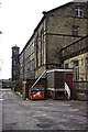
West Street, Stone Chair
Alleyway behind a row of terraced houses on the east side of West Street.
Image: © Paul Glazzard
Taken: 1 Apr 2007
0.04 miles
10
Stone Chair mile stone
Mile stone that doubles up as a place to rest. Probably situated where the roundabout is at the present time before being moved to its present location, and also giving the local area its name.
Image: © Alan Bate
Taken: 9 Sep 2014
0.04 miles