IMAGES TAKEN NEAR TO
Oaklands Avenue, HALIFAX, HX3 7HS
Introduction
This page details the photographs taken nearby to Oaklands Avenue, HX3 7HS by members of the Geograph project.
The Geograph project started in 2005 with the aim of publishing, organising and preserving representative images for every square kilometre of Great Britain, Ireland and the Isle of Man.

There are currently over 7.5m images from over14,400 individuals and you can help contribute to the project by visiting https://www.geograph.org.uk
Image Map
Images are licensed for reuse under creativecommons.org/licenses/by-sa/2.0
Notes
- Clicking on the map will re-center to the selected point.
- The higher the marker number, the further away the image location is from the centre of the postcode.
Image Listing (129 Images Found)
Images are licensed for reuse under creativecommons.org/licenses/by-sa/2.0
Image
Details
Distance
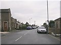
1
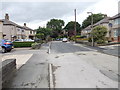
Oaklands Avenue - looking towards Bradford Road
Image: © Betty Longbottom
Taken: 13 Aug 2012
0.01 miles
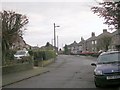
3
Square, Bradford Road, Northowram
A very short name for this group of houses; the name 'Square' seems to have referred to the area at the eastern end of Lydgate before 20th century development, and the 1908 map shows this as an isolated group of cottages with a smithy behind. There is a bus stop served by buses from Leeds and Bradford to Halifax.
Image: © Stephen Craven
Taken: 12 Mar 2022
0.06 miles
4
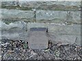
Cast iron GPO marker post, Bradford Road, Northowram
This was a Post Office marker for a buried Telegraph cable joint. From 1897 to about 1925 the Post Office were creating an underground network of telegraph cables, being more resilient (particularly to weather) than aerial cables on poles. The cables came in 150 or 176 yard sections, and were joined end-on on-site, and the joints (as the rest of the cable) buried directly in the ground. It was assumed that any faults would most likely be at joints so these were marked for easy location later; below the "ft.in." cast marking, there would have been numeral inserts identifying the horizontal distance in front of the marker where the cable lay. (text: credit Derek Pattenson of gpo-markers.derektp.co.uk )
Image: © Stephen Craven
Taken: 12 Mar 2022
0.06 miles

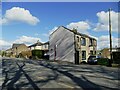
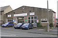
7
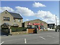
Northowram Garage, Bradford Road,
See also Image, the signs have been replaced since then.
Image: © Stephen Craven
Taken: 12 Mar 2022
0.07 miles
8
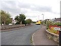
Greencroft Avenue - Westercroft Lane
Image: © Betty Longbottom
Taken: 13 Aug 2012
0.07 miles
9
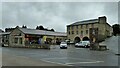
New retail store
A local supermarket on Bradford Road at The Tannery, a site that was originally was a brewery
Image: © Kevin Waterhouse
Taken: 22 Jul 2023
0.08 miles
10
Northowram Garage - Bradford Road
Image: © Betty Longbottom
Taken: 12 Dec 2009
0.08 miles