IMAGES TAKEN NEAR TO
Stanage Lane, HALIFAX, HX3 7BL
Introduction
This page details the photographs taken nearby to Stanage Lane, HX3 7BL by members of the Geograph project.
The Geograph project started in 2005 with the aim of publishing, organising and preserving representative images for every square kilometre of Great Britain, Ireland and the Isle of Man.

There are currently over 7.5m images from over14,400 individuals and you can help contribute to the project by visiting https://www.geograph.org.uk
Image Map
Images are licensed for reuse under creativecommons.org/licenses/by-sa/2.0
Notes
- Clicking on the map will re-center to the selected point.
- The higher the marker number, the further away the image location is from the centre of the postcode.
Image Listing (47 Images Found)
Images are licensed for reuse under creativecommons.org/licenses/by-sa/2.0
Image
Details
Distance
2
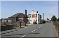
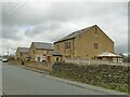
The Windmill Inn, Stanage Lane, Shelf
Built in 1897, with a later function room behind it. The windmill was in Burned Road. It was a corn mill built by the Sugden family in 1789, and still existed, although disused, c.1950.
Image: © Humphrey Bolton
Taken: 25 Jul 2006
0.04 miles
4
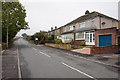
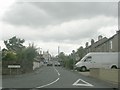
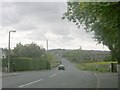
Modern houses on Stanage Lane
At around 280m elevation, these are some of the highest houses in Shelf (though not quite as high as nearby Queensbury).
Image: © Stephen Craven
Taken: 12 Mar 2022
0.05 miles

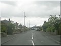
7
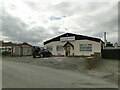
Lion Gate House, Stanage Lane
Home to the Crusty Pie Company, and named after a nearby historic structure Image
Image: © Stephen Craven
Taken: 12 Mar 2022
0.10 miles
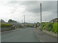
8
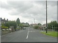
Soaper Lane - viewed from Shelf Moor
Image: © Betty Longbottom
Taken: 7 Jun 2009
0.10 miles