IMAGES TAKEN NEAR TO
Old Lane, HALIFAX, HX3 6TG
Introduction
This page details the photographs taken nearby to Old Lane, HX3 6TG by members of the Geograph project.
The Geograph project started in 2005 with the aim of publishing, organising and preserving representative images for every square kilometre of Great Britain, Ireland and the Isle of Man.

There are currently over 7.5m images from over14,400 individuals and you can help contribute to the project by visiting https://www.geograph.org.uk
Image Map
Images are licensed for reuse under creativecommons.org/licenses/by-sa/2.0
Notes
- Clicking on the map will re-center to the selected point.
- The higher the marker number, the further away the image location is from the centre of the postcode.
Image Listing (199 Images Found)
Images are licensed for reuse under creativecommons.org/licenses/by-sa/2.0
Image
Details
Distance
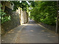
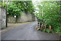
2
On Old Lane
Hemmed in by trees and retaining walls, the lane takes on a tunnel resemblance at this point.
Image: © Chris Heaton
Taken: 14 Jun 2020
0.02 miles
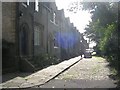
3
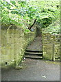
Halifax FP438 at Old Lane
This path is surfaced with stone setts, and there are stone steps. It is on the 1852 six-inch map. There is no footpath sign.
Image: © Humphrey Bolton
Taken: 15 May 2017
0.02 miles
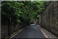
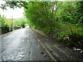
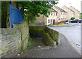
4
Old Lane - Raised pavement near to Mill Lane
Image: © Alan Longbottom
Taken: 4 Mar 2008
0.02 miles
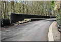
5
Stable Lane (Halifax FP443) at Old Lane
This path does have footpath sign, unlike most paths in this area.
Image: © Humphrey Bolton
Taken: 15 May 2017
0.03 miles
6
Unofficial path off Old Lane, Halifax, leading to FP751
This is the lower end of the track shown in Image
Image: © Humphrey Bolton
Taken: 15 May 2017
0.03 miles
8
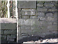
Old Lane - Bench Mark on raised pavement
Image: © Alan Longbottom
Taken: 4 Mar 2008
0.04 miles
9
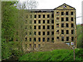
Old Lane Mill, Halifax
Derelict but Listed Grade II* worsted mill. Built in 1825-28 for James Ackroyd and acquired by the Rawson family in 1836. The mill includes an internal beam engine house and there is a separate boiler house with chimney. The Ovenden Beck is seen in the left foreground. These buildings are clearly dangerous and should not be entered. There is a well trodden path through the site.
Image: © Chris Allen
Taken: 6 May 2023
0.05 miles
10
Halifax FP438 at Wells Close
This goes down to Old Lane (see Image). The path is on the 1852 six-inch map and continued (behind the camera) as a field path on the line of the present Rawson Street North to Booth Bank Road, which was then called Bradford New Road. There is no footpath sign.
Image: © Humphrey Bolton
Taken: 15 May 2017
0.05 miles