IMAGES TAKEN NEAR TO
Royd Lane, HALIFAX, HX3 6RX
Introduction
This page details the photographs taken nearby to Royd Lane, HX3 6RX by members of the Geograph project.
The Geograph project started in 2005 with the aim of publishing, organising and preserving representative images for every square kilometre of Great Britain, Ireland and the Isle of Man.

There are currently over 7.5m images from over14,400 individuals and you can help contribute to the project by visiting https://www.geograph.org.uk
Image Map
Images are licensed for reuse under creativecommons.org/licenses/by-sa/2.0
Notes
- Clicking on the map will re-center to the selected point.
- The higher the marker number, the further away the image location is from the centre of the postcode.
Image Listing (59 Images Found)
Images are licensed for reuse under creativecommons.org/licenses/by-sa/2.0
Image
Details
Distance
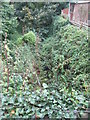
2
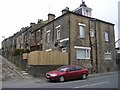
Kimberley Street - Churn Milk Lane
Image: © Betty Longbottom
Taken: 28 May 2010
0.04 miles
3
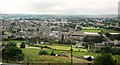
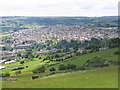
View near Ovenden
From the A674 looking across the Ovenden Brook valley.
Image: © Derek Harper
Taken: 3 Jul 2014
0.04 miles
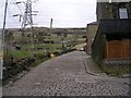
4
Churn Milk Lane Bridge - Shay Lane, Holmfield
Image: © Betty Longbottom
Taken: 25 Mar 2008
0.05 miles
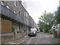
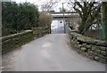
6
Drake's Industrial Estate - Shay Lane
Image: © Betty Longbottom
Taken: 16 Oct 2013
0.07 miles
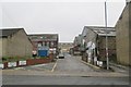
7
Churn Milk Lane - Shay Lane, Holmfield
Image: © Betty Longbottom
Taken: 25 Mar 2008
0.07 miles
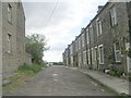
8
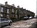
Crossley Terrace North - Shay Lane, Holmfield
Image: © Betty Longbottom
Taken: 25 Mar 2008
0.07 miles
10
Crossley Terrace South - Shay Lane, Holmfield
Image: © Betty Longbottom
Taken: 25 Mar 2008
0.07 miles