IMAGES TAKEN NEAR TO
Sutcliffe Terrace, HALIFAX, HX3 6JY
Introduction
This page details the photographs taken nearby to Sutcliffe Terrace, HX3 6JY by members of the Geograph project.
The Geograph project started in 2005 with the aim of publishing, organising and preserving representative images for every square kilometre of Great Britain, Ireland and the Isle of Man.

There are currently over 7.5m images from over14,400 individuals and you can help contribute to the project by visiting https://www.geograph.org.uk
Image Map
Images are licensed for reuse under creativecommons.org/licenses/by-sa/2.0
Notes
- Clicking on the map will re-center to the selected point.
- The higher the marker number, the further away the image location is from the centre of the postcode.
Image Listing (192 Images Found)
Images are licensed for reuse under creativecommons.org/licenses/by-sa/2.0
Image
Details
Distance
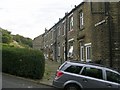
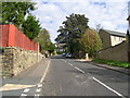
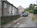
2
Range Bank - viewed from Range Lane
Image: © Betty Longbottom
Taken: 5 Oct 2009
0.01 miles
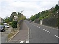
3
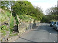
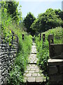
Claremont Road Footpath at Range Bank, Halifax
This is one of many urban paths in Halifax that are adopted highways rather than public footpaths.
Image: © Humphrey Bolton
Taken: 1 May 2017
0.02 miles
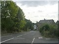
5
Footpath from Range Bank to Claremount Road
Image: © Betty Longbottom
Taken: 4 Jun 2013
0.03 miles
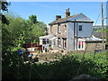
6
Range Lane - viewed from Range Street
Image: © Betty Longbottom
Taken: 5 Oct 2009
0.04 miles
10
Range Bank - viewed from Range Lane
Image: © Betty Longbottom
Taken: 5 Oct 2009
0.05 miles