IMAGES TAKEN NEAR TO
Lake View, HALIFAX, HX3 6EP
Introduction
This page details the photographs taken nearby to Lake View, HX3 6EP by members of the Geograph project.
The Geograph project started in 2005 with the aim of publishing, organising and preserving representative images for every square kilometre of Great Britain, Ireland and the Isle of Man.

There are currently over 7.5m images from over14,400 individuals and you can help contribute to the project by visiting https://www.geograph.org.uk
Image Map
Images are licensed for reuse under creativecommons.org/licenses/by-sa/2.0
Notes
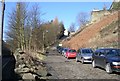
- Clicking on the map will re-center to the selected point.
- The higher the marker number, the further away the image location is from the centre of the postcode.
Image Listing (322 Images Found)
Images are licensed for reuse under creativecommons.org/licenses/by-sa/2.0
Image
Details
Distance
1
Track from Old Lane to Boothtown Road
Image: © Betty Longbottom
Taken: 4 Mar 2008
0.01 miles
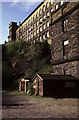
2

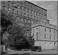
Haley Hill Mills, Halifax
Haley Hill Mills are the large block in the background and are seen across parts of Dean Clough Mills in the foreground.
Image: © Chris Allen
Taken: 18 Jul 2015
0.02 miles
3
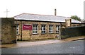
All Souls New Church - Boothtown Road
Image: © Betty Longbottom
Taken: 7 Nov 2007
0.03 miles
4
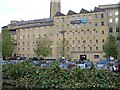
Haley Hill Mills, Halifax
Later known as Holroyd's Mill.
Image: © Chris Allen
Taken: 3 May 1987
0.03 miles
5
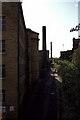
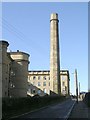
Old Lane, Halifax
Round the back of Dean Clough Mills with the famous spiky chimney in the distance.
Image: © Chris Allen
Taken: 3 May 1987
0.04 miles
6
Haley Hill Mills, Halifax
Later known as Holroyd's Mill. The building with the tall windows at the foot of the cliff has the appearance of a former beam engine house and presumably drove the mill by shaft and gearing. It is a magnificent survival and I would appreciate any further information.
Image: © Chris Allen
Taken: 18 Jul 2015
0.04 miles
8
Bowling Dyke Mill Chimney - Dean Clough
Image: © Betty Longbottom
Taken: 4 Mar 2008
0.05 miles
9
Woodside Road Track, Halifax
This is an unadopted street that, from map evidence, was made when the Woodside housing estate was built in the grounds of a house called Woodside between 1893 and 1907. It is also Halifax Bridleway 581 and a commuter car park.
Image: © Humphrey Bolton
Taken: 15 May 2017
0.05 miles
10
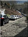
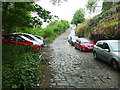
Lane off Woodside Road
A steep lane leading down to Old Lane which despite the gradient and surface appears to have become a commuters' car park.
Image: © Alan Murray-Rust
Taken: 7 Mar 2017
0.05 miles