IMAGES TAKEN NEAR TO
Ada Street, HALIFAX, HX3 6DS
Introduction
This page details the photographs taken nearby to Ada Street, HX3 6DS by members of the Geograph project.
The Geograph project started in 2005 with the aim of publishing, organising and preserving representative images for every square kilometre of Great Britain, Ireland and the Isle of Man.

There are currently over 7.5m images from over14,400 individuals and you can help contribute to the project by visiting https://www.geograph.org.uk
Image Map
Images are licensed for reuse under creativecommons.org/licenses/by-sa/2.0
Notes
- Clicking on the map will re-center to the selected point.
- The higher the marker number, the further away the image location is from the centre of the postcode.
Image Listing (269 Images Found)
Images are licensed for reuse under creativecommons.org/licenses/by-sa/2.0
Image
Details
Distance
5
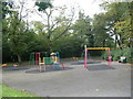
St Bernard's Church Hall - Range Lane
Image: © Betty Longbottom
Taken: 5 Oct 2009
0.02 miles
6
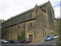
Catholic Church of the Sacred Heart & St Bernard - Range Lane
Image: © Betty Longbottom
Taken: 5 Oct 2009
0.03 miles
7
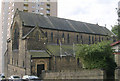
Catholic Church of the Sacred Heart & St Bernard - Range Lane
Image: © Betty Longbottom
Taken: 5 Oct 2009
0.03 miles
10
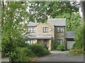
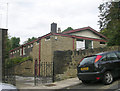
St Bernard's Presbytery - Range Lane
Image: © Betty Longbottom
Taken: 5 Oct 2009
0.04 miles