IMAGES TAKEN NEAR TO
Horley Green Road, HALIFAX, HX3 6AS
Introduction
This page details the photographs taken nearby to Horley Green Road, HX3 6AS by members of the Geograph project.
The Geograph project started in 2005 with the aim of publishing, organising and preserving representative images for every square kilometre of Great Britain, Ireland and the Isle of Man.

There are currently over 7.5m images from over14,400 individuals and you can help contribute to the project by visiting https://www.geograph.org.uk
Image Map
Images are licensed for reuse under creativecommons.org/licenses/by-sa/2.0
Notes
- Clicking on the map will re-center to the selected point.
- The higher the marker number, the further away the image location is from the centre of the postcode.
Image Listing (141 Images Found)
Images are licensed for reuse under creativecommons.org/licenses/by-sa/2.0
Image
Details
Distance
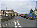
1
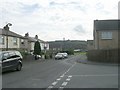
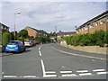
Horley Green Road - viewed from Belgrave Avenue
Image: © Betty Longbottom
Taken: 5 Oct 2009
0.01 miles
2
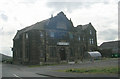
The Claremount Club - Belgrave Avenue
Built as the Liberal Club in 1897.
Image: © Betty Longbottom
Taken: 5 Oct 2009
0.02 miles
3
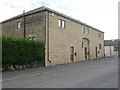
Horley Green Barn - Horley Green Road
Image: © Betty Longbottom
Taken: 5 Oct 2009
0.04 miles
4
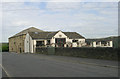
Lower Horley Green Farm - Horley Green Road
Image: © Betty Longbottom
Taken: 5 Oct 2009
0.04 miles
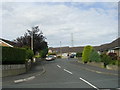
5
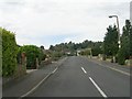
Horley Green Road - viewed from Belgrave Avenue
Image: © Betty Longbottom
Taken: 5 Oct 2009
0.05 miles
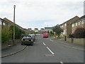
7
Belgrave Crescent - Belgrave Avenue
Image: © Betty Longbottom
Taken: 5 Oct 2009
0.06 miles
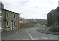
10
Jerwood Hill Close - Horley Green Road
Image: © Betty Longbottom
Taken: 5 Oct 2009
0.08 miles