IMAGES TAKEN NEAR TO
Friendly Street, HALIFAX, HX3 5QE
Introduction
This page details the photographs taken nearby to Friendly Street, HX3 5QE by members of the Geograph project.
The Geograph project started in 2005 with the aim of publishing, organising and preserving representative images for every square kilometre of Great Britain, Ireland and the Isle of Man.

There are currently over 7.5m images from over14,400 individuals and you can help contribute to the project by visiting https://www.geograph.org.uk
Image Map
Images are licensed for reuse under creativecommons.org/licenses/by-sa/2.0
Notes
- Clicking on the map will re-center to the selected point.
- The higher the marker number, the further away the image location is from the centre of the postcode.
Image Listing (106 Images Found)
Images are licensed for reuse under creativecommons.org/licenses/by-sa/2.0
Image
Details
Distance
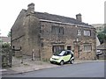
2
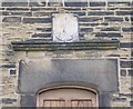
Sundial & Lintel - House - Friendly Fold Street
The date, 1709, can be seen over the door.
Image: © Betty Longbottom
Taken: 24 Aug 2009
0.02 miles
3
House - Friendly Fold Road
The datestone over the door, beneath the sundial, shows 1709.
Image: © Betty Longbottom
Taken: 24 Aug 2009
0.03 miles
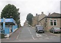
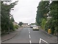
5
Oakdale Close - looking towards Ovenden Road
Image: © Betty Longbottom
Taken: 13 Sep 2013
0.03 miles
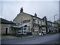
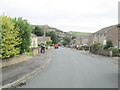
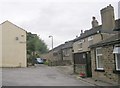
6
Friendly Street - Friendly Fold Road
Image: © Betty Longbottom
Taken: 24 Aug 2009
0.03 miles
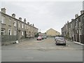
7
Friendly Fold - Friendly Fold Road
Image: © Betty Longbottom
Taken: 24 Aug 2009
0.04 miles
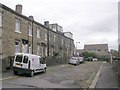
8
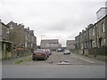
Bethell Street - Friendly Fold Road
Image: © Betty Longbottom
Taken: 24 Aug 2009
0.04 miles