IMAGES TAKEN NEAR TO
Ovenden Way, HALIFAX, HX3 5NU
Introduction
This page details the photographs taken nearby to Ovenden Way, HX3 5NU by members of the Geograph project.
The Geograph project started in 2005 with the aim of publishing, organising and preserving representative images for every square kilometre of Great Britain, Ireland and the Isle of Man.

There are currently over 7.5m images from over14,400 individuals and you can help contribute to the project by visiting https://www.geograph.org.uk
Image Map
Images are licensed for reuse under creativecommons.org/licenses/by-sa/2.0
Notes
- Clicking on the map will re-center to the selected point.
- The higher the marker number, the further away the image location is from the centre of the postcode.
Image Listing (67 Images Found)
Images are licensed for reuse under creativecommons.org/licenses/by-sa/2.0
Image
Details
Distance
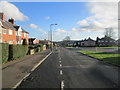
1
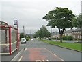
Ovenden Way - viewed from Nursery Lane
Image: © Betty Longbottom
Taken: 24 Aug 2009
0.02 miles
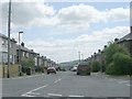
2
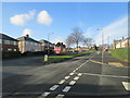
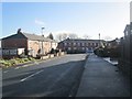
Ovenden Way - viewed from Vegal Crescent
Image: © Betty Longbottom
Taken: 13 Jan 2014
0.03 miles
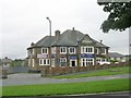
5
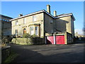
St Malachy's Presbytery - Nursery Lane
Image: © Betty Longbottom
Taken: 13 Jan 2014
0.06 miles
7
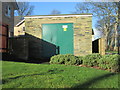
Electricity Substation No 1295 - Nursery Lane
Image: © Betty Longbottom
Taken: 13 Jan 2014
0.06 miles
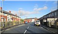
8
Ovenden Way - viewed from Vegal Crescent
Image: © Betty Longbottom
Taken: 13 Jan 2014
0.06 miles
10
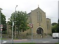
Our Lady of Lourdes & St Malachy Catholic Church - Nursery Lane
Image: © Betty Longbottom
Taken: 24 Aug 2009
0.07 miles