IMAGES TAKEN NEAR TO
Shroggs Road, HALIFAX, HX3 5HA
Introduction
This page details the photographs taken nearby to Shroggs Road, HX3 5HA by members of the Geograph project.
The Geograph project started in 2005 with the aim of publishing, organising and preserving representative images for every square kilometre of Great Britain, Ireland and the Isle of Man.

There are currently over 7.5m images from over14,400 individuals and you can help contribute to the project by visiting https://www.geograph.org.uk
Image Map
Images are licensed for reuse under creativecommons.org/licenses/by-sa/2.0
Notes
- Clicking on the map will re-center to the selected point.
- The higher the marker number, the further away the image location is from the centre of the postcode.
Image Listing (115 Images Found)
Images are licensed for reuse under creativecommons.org/licenses/by-sa/2.0
Image
Details
Distance
1
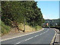
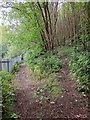
Shroggs Road, Halifax
A view of Shroggs Road, heading into Halifax.
To the left of the image, a steep path climbs away from the road.
Image: © Malc McDonald
Taken: 29 Aug 2016
0.04 miles
2
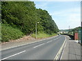
Shroggs Road and footpath to Shroggs Park, Halifax
Image: © Humphrey Bolton
Taken: 19 Jun 2017
0.04 miles
4
Junction of paths, Birks Hall Lane, Halifax
Halifax FP733 goes alongside the fence on its way to Shroggs Road. The track on the left doubles back and climbs up to Pellon Lane near the junction with Angel Road. The track in the middle is the continuation of Birks Hall Lane.
Image: © Humphrey Bolton
Taken: 6 Mar 2019
0.05 miles
5
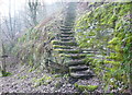
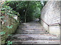
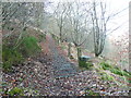
Steps on Halifax FP733 in Snake Hill Wood
Whilst you can take an easy stroll on the zig-zag track the official line of the footpath is via these steps.
Image: © Humphrey Bolton
Taken: 24 Feb 2019
0.05 miles
7
The westernmost part of Birks Hall Lane, Halifax
This track soon enters the woodland on the landfill site and ends on a wet and muddy slope. What looks like a parallel path on the left does not go far and seems to be a terrace made along the hillside.
Image: © Humphrey Bolton
Taken: 6 Mar 2019
0.06 miles
8
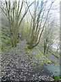
Path or berm, Snake Hill Wood, Halifax
I thought that this was part of Birks Hall Lane, but later found that the lane is further down the hillside.
Image: © Humphrey Bolton
Taken: 24 Feb 2019
0.06 miles
9
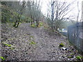
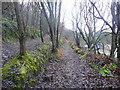
Birks Hall Lane
A fork on the path which runs along the valley side above the Hebble Brook valley, here beside a steel fence behind the Elizabeth Industrial Estate.
Image: © Derek Harper
Taken: 3 Jul 2014
0.06 miles
10
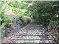
Pellon Lane Footpath, Snake Hill Wood
Whilst not a public footpath it is an adopted path, and reaches Pellon Lane at Trinity Church. Although this was a lovely sunny day, this hillside remains in shade in the winter. This image Image taken in summer is a bit brighter! Birks Hall Lane carries on near the bottom of the steep part of the hillside.
Image: © Humphrey Bolton
Taken: 24 Feb 2019
0.07 miles