IMAGES TAKEN NEAR TO
Woodhouse Lane, HALIFAX, HX3 0UW
Introduction
This page details the photographs taken nearby to Woodhouse Lane, HX3 0UW by members of the Geograph project.
The Geograph project started in 2005 with the aim of publishing, organising and preserving representative images for every square kilometre of Great Britain, Ireland and the Isle of Man.

There are currently over 7.5m images from over14,400 individuals and you can help contribute to the project by visiting https://www.geograph.org.uk
Image Map
Images are licensed for reuse under creativecommons.org/licenses/by-sa/2.0
Notes
- Clicking on the map will re-center to the selected point.
- The higher the marker number, the further away the image location is from the centre of the postcode.
Image Listing (53 Images Found)
Images are licensed for reuse under creativecommons.org/licenses/by-sa/2.0
Image
Details
Distance
1
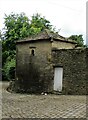
Dovecote to Wood Hall
In Woodhouse Lane, Copley
Image: © Kevin Waterhouse
Taken: 6 Sep 2020
0.03 miles
3

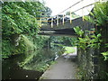
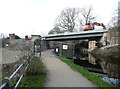
Calder & Hebble Navigation
Looking eastwards along the Calder & Hebble Navigation from the bridge at SE078232.
Image: © Peter Crump
Taken: 31 Jan 2006
0.12 miles
4
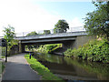
Calder & Hebble Navigation
With the bridge which carries Hollins Lane
Image: © Alexander P Kapp
Taken: 25 Sep 2008
0.13 miles
5
Hollas Lane bridge over the Calder and Hebble Canal
The lane leads down to a new bridge over the river Calder Image This bridge was also rebuilt in 2012 Image and replaced an earlier structure Image
Image: © Stephen Craven
Taken: 6 Jul 2015
0.15 miles
6
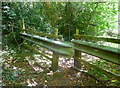
Unusual squeeze stile on Halifax FP675, Skircoat
Image: © Humphrey Bolton
Taken: 2 Aug 2018
0.15 miles
7
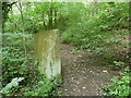
Stone slab on Halifax FP676, Skircoat
This is on an old field boundary and was probably part of a stile.
Image: © Humphrey Bolton
Taken: 2 Aug 2018
0.15 miles
8
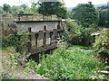
Sluice
Use to work the millrace for the mill which was on the east side of Sterne Bridge, Hollins Lane,
Image: © Alexander P Kapp
Taken: 25 Sep 2008
0.16 miles
9
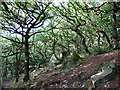
Deformed trees in Scarr Wood
A combination of a steep hillside and exposure to prevailing south-westerly winds is presumably responsible for the grotesque forms of some of these tree-trunks.
Scarr Wood is an open access nature reserve owned by Calderdale Council. Their website http://www.calderdale.gov.uk/environment/countryside/naturereserves/long-scarr-wood.html describes it as "typical Scarp Oak woodland found throughout Calderdale".
Image: © Stephen Craven
Taken: 29 Aug 2010
0.16 miles
10
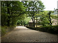
New canal bridge under construction, Copley
This will carry the access road to a business park on the site of Milner Royd Sewage Works.
Image: © Humphrey Bolton
Taken: 15 Mar 2012
0.16 miles