IMAGES TAKEN NEAR TO
Huddersfield Road, HALIFAX, HX3 0PF
Introduction
This page details the photographs taken nearby to Huddersfield Road, HX3 0PF by members of the Geograph project.
The Geograph project started in 2005 with the aim of publishing, organising and preserving representative images for every square kilometre of Great Britain, Ireland and the Isle of Man.

There are currently over 7.5m images from over14,400 individuals and you can help contribute to the project by visiting https://www.geograph.org.uk
Image Map
Images are licensed for reuse under creativecommons.org/licenses/by-sa/2.0
Notes
- Clicking on the map will re-center to the selected point.
- The higher the marker number, the further away the image location is from the centre of the postcode.
Image Listing (167 Images Found)
Images are licensed for reuse under creativecommons.org/licenses/by-sa/2.0
Image
Details
Distance
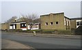
1
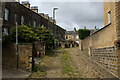
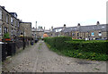
Back of Stafford Parade, Halifax
Cobbled alleyways behind rows of terraced houses
Image: © Chris Heaton
Taken: 15 Aug 2021
0.02 miles
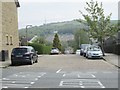
2
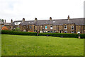
A green at the rear of Stafford Parade, Dryclough Lane and Huddersfield Road, Halifax
Image: © habiloid
Taken: 4 May 2023
0.02 miles
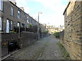
3
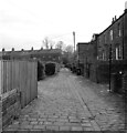
The alley at the rear of Stafford Parade, Halifax
Image: © habiloid
Taken: 4 May 2023
0.02 miles
5
The alley at the rear of Stafford Parade, Halifax
Image: © habiloid
Taken: 4 May 2023
0.02 miles
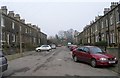
6
Stafford Square - Huddersfield Road
Image: © Betty Longbottom
Taken: 17 May 2013
0.03 miles
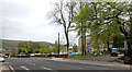
8
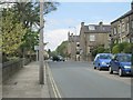
Dryclough Lane - Huddersfield Road
Image: © Betty Longbottom
Taken: 17 May 2013
0.04 miles
9
St Andrew's Methodist Church - Huddersfield Road
Image: © Betty Longbottom
Taken: 20 Feb 2008
0.05 miles
10
The entrance to Calderdale Royal Hospital (A646), Dryclough Lane, Halifax
Image: © habiloid
Taken: 4 May 2023
0.05 miles