IMAGES TAKEN NEAR TO
Bradshaw, HALIFAX, HX2 9XE
Introduction
This page details the photographs taken nearby to HX2 9XE by members of the Geograph project.
The Geograph project started in 2005 with the aim of publishing, organising and preserving representative images for every square kilometre of Great Britain, Ireland and the Isle of Man.

There are currently over 7.5m images from over14,400 individuals and you can help contribute to the project by visiting https://www.geograph.org.uk
Image Map
Images are licensed for reuse under creativecommons.org/licenses/by-sa/2.0
Notes
- Clicking on the map will re-center to the selected point.
- The higher the marker number, the further away the image location is from the centre of the postcode.
Image Listing (7 Images Found)
Images are licensed for reuse under creativecommons.org/licenses/by-sa/2.0
Image
Details
Distance
1
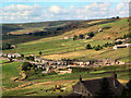
Bradshaw village
Viewed from Roper Lane. Ovenden Moor windfarm on the skyline 4km to the WNW.
Image: © David Spencer
Taken: 19 Aug 2005
0.10 miles
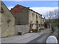
2

Bradshaw Village
A linear village along Bradshaw Lane. Ovenden Moor wind farm is on the skyline beyond
Image: © Kevin Waterhouse
Taken: 4 Oct 2010
0.11 miles
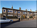
4
The Bradshaw Tavern - Bradshaw Lane, Bradshaw
Image: © Betty Longbottom
Taken: 25 Mar 2008
0.17 miles
5
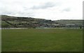
Bradshaw Cricket Club - Bradshaw Lane
Image: © Betty Longbottom
Taken: 25 Mar 2008
0.19 miles
6
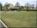
Tetley Memorial Park Bowling Crown Green - Bradshaw Lane, Bradshaw
Image: © Betty Longbottom
Taken: 25 Mar 2008
0.21 miles
7
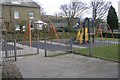
Bradshaw Playground - Bradshaw Lane
Image: © Betty Longbottom
Taken: 25 Mar 2008
0.24 miles