IMAGES TAKEN NEAR TO
HX2 8US
Introduction
This page details the photographs taken nearby to HX2 8US by members of the Geograph project.
The Geograph project started in 2005 with the aim of publishing, organising and preserving representative images for every square kilometre of Great Britain, Ireland and the Isle of Man.

There are currently over 7.5m images from over14,400 individuals and you can help contribute to the project by visiting https://www.geograph.org.uk
Image Map
Images are licensed for reuse under creativecommons.org/licenses/by-sa/2.0
Notes
- Clicking on the map will re-center to the selected point.
- The higher the marker number, the further away the image location is from the centre of the postcode.
Image Listing (55 Images Found)
Images are licensed for reuse under creativecommons.org/licenses/by-sa/2.0
Image
Details
Distance
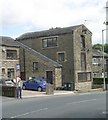
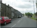
2
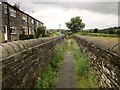
Path beside Providence Row
Halifax footpath 074 sets out from Hays Lane along this walled path towards Stod Fold.
Image: © Derek Harper
Taken: 3 Jul 2014
0.07 miles
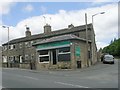
3
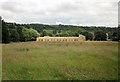
Hebble Brook Business Park
Hebble Brook Business Park is a purpose-built office campus and computer centre, home to Swinton Insurance. This is one of four blocks built around a lake, and seen here from Halifax footpath 074 as shown in Image
Image: © Derek Harper
Taken: 3 Jul 2014
0.07 miles
4
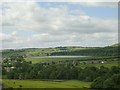
Mixenden Reservoir - viewed from Lane Head Lane
Image: © Betty Longbottom
Taken: 12 Jun 2010
0.08 miles

10
Clough Lane - viewed from Mill Lane
Image: © Betty Longbottom
Taken: 12 Jun 2010
0.09 miles