IMAGES TAKEN NEAR TO
Furness Drive, HALIFAX, HX2 8NE
Introduction
This page details the photographs taken nearby to Furness Drive, HX2 8NE by members of the Geograph project.
The Geograph project started in 2005 with the aim of publishing, organising and preserving representative images for every square kilometre of Great Britain, Ireland and the Isle of Man.

There are currently over 7.5m images from over14,400 individuals and you can help contribute to the project by visiting https://www.geograph.org.uk
Image Map
Images are licensed for reuse under creativecommons.org/licenses/by-sa/2.0
Notes
- Clicking on the map will re-center to the selected point.
- The higher the marker number, the further away the image location is from the centre of the postcode.
Image Listing (51 Images Found)
Images are licensed for reuse under creativecommons.org/licenses/by-sa/2.0
Image
Details
Distance
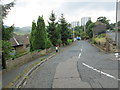
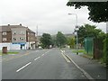
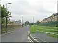
1
Furness Drive - viewed from Bank Edge Road
Image: © Betty Longbottom
Taken: 1 Aug 2014
0.02 miles
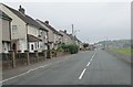
5
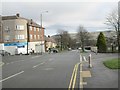
Bank Edge Road - looking towards Cousin Lane
Image: © Betty Longbottom
Taken: 13 Jan 2014
0.07 miles
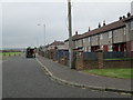
6
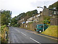
Crag Lane
The row of houses is called Rake Bank
Image: © Alexander P Kapp
Taken: 3 Sep 2009
0.08 miles
7
Turner Avenue South - Bank Edge Road
Image: © Betty Longbottom
Taken: 24 Aug 2009
0.09 miles
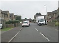
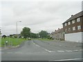
9
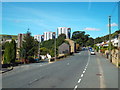
Crag Lane, Halifax
Crag Lane on the outskirts of Halifax, at its junction with Roper Green.
In the background are four high-rise blocks of flats on Mixenden Road.
Image: © Malc McDonald
Taken: 29 Aug 2016
0.11 miles