IMAGES TAKEN NEAR TO
St. Winifreds Close, HALIFAX, HX2 8LR
Introduction
This page details the photographs taken nearby to St. Winifreds Close, HX2 8LR by members of the Geograph project.
The Geograph project started in 2005 with the aim of publishing, organising and preserving representative images for every square kilometre of Great Britain, Ireland and the Isle of Man.

There are currently over 7.5m images from over14,400 individuals and you can help contribute to the project by visiting https://www.geograph.org.uk
Image Map
Images are licensed for reuse under creativecommons.org/licenses/by-sa/2.0
Notes
- Clicking on the map will re-center to the selected point.
- The higher the marker number, the further away the image location is from the centre of the postcode.
Image Listing (95 Images Found)
Images are licensed for reuse under creativecommons.org/licenses/by-sa/2.0
Image
Details
Distance
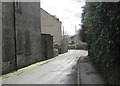
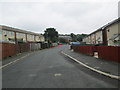
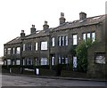
1
St Winifreds Close - Turner Avenue North
Image: © Betty Longbottom
Taken: 24 Aug 2009
0.01 miles
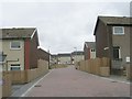
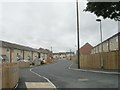
2
Broomhead Close - Turner Avenue North
Image: © Betty Longbottom
Taken: 24 Aug 2009
0.02 miles
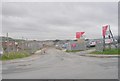
3
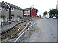
Roadworks on Turner Road North
The Dudley Crescent estate is in the throws of refurbishment, these roadworks are part of it.
Image: © Alexander P Kapp
Taken: 25 Sep 2008
0.02 miles
4
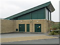
Electricity Substation No 49762 - Turner Avenue North
This forms a part of Morrison's Supermarket.
Image: © Betty Longbottom
Taken: 1 Aug 2014
0.04 miles
5
Church Close - Turner Avenue North
Image: © Betty Longbottom
Taken: 24 Aug 2009
0.05 miles
6
Church Close - looking towards Turner Avenue North
Image: © Betty Longbottom
Taken: 1 Aug 2014
0.05 miles
7
Furness Avenue - Turner Avenue North
Image: © Betty Longbottom
Taken: 24 Aug 2009
0.07 miles
9
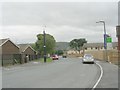
Turner Avenue North - viewed from Solstice Way
Image: © Betty Longbottom
Taken: 24 Aug 2009
0.08 miles