IMAGES TAKEN NEAR TO
Keighley Road, HALIFAX, HX2 8JA
Introduction
This page details the photographs taken nearby to Keighley Road, HX2 8JA by members of the Geograph project.
The Geograph project started in 2005 with the aim of publishing, organising and preserving representative images for every square kilometre of Great Britain, Ireland and the Isle of Man.

There are currently over 7.5m images from over14,400 individuals and you can help contribute to the project by visiting https://www.geograph.org.uk
Image Map
Images are licensed for reuse under creativecommons.org/licenses/by-sa/2.0
Notes
- Clicking on the map will re-center to the selected point.
- The higher the marker number, the further away the image location is from the centre of the postcode.
Image Listing (97 Images Found)
Images are licensed for reuse under creativecommons.org/licenses/by-sa/2.0
Image
Details
Distance
4
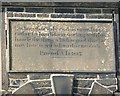
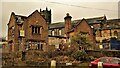
Plaque on Illingworth Gaol, Wrigley Hill
The building is shown on Image It had cells for four felons. Presumably it was built by the township of Ovenden, of which Illingworth was a part. 'Let him that stole steal no more but / rather let him labour working with his / hands the thing that is good is that he / may have to give to him that needeth. / Erected A.D. 1823'.
Image: © Humphrey Bolton
Taken: 26 Mar 2009
0.05 miles
5
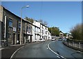
Wrigley Hill (Keighley Road A629), Illingworth
The three-storey white building has a datestone 'N H G 1844'.
Image: © Humphrey Bolton
Taken: 26 Mar 2009
0.05 miles
6
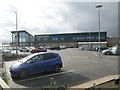
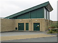
Morrisons Supermarket - Keighley Road
Image: © Betty Longbottom
Taken: 24 Feb 2014
0.05 miles
7
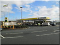
Morrisons Petrol Station - Keighley Road
Image: © Betty Longbottom
Taken: 24 Feb 2014
0.07 miles
8
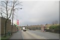
Keighley Road - viewed from Cousin Lane
Image: © Betty Longbottom
Taken: 13 Jan 2014
0.08 miles
9
Electricity Substation No 49762 - Turner Avenue North
This forms a part of Morrison's Supermarket.
Image: © Betty Longbottom
Taken: 1 Aug 2014
0.08 miles
10
Demolition of Talbot Inn
The middle part of the inn has gone apart from the steel beam that tied the outer wings together. Housing now occupies this site
Image: © Kevin Waterhouse
Taken: 25 Jan 2009
0.08 miles