IMAGES TAKEN NEAR TO
Keighley Drive, HALIFAX, HX2 8HD
Introduction
This page details the photographs taken nearby to Keighley Drive, HX2 8HD by members of the Geograph project.
The Geograph project started in 2005 with the aim of publishing, organising and preserving representative images for every square kilometre of Great Britain, Ireland and the Isle of Man.

There are currently over 7.5m images from over14,400 individuals and you can help contribute to the project by visiting https://www.geograph.org.uk
Image Map
Images are licensed for reuse under creativecommons.org/licenses/by-sa/2.0
Notes
- Clicking on the map will re-center to the selected point.
- The higher the marker number, the further away the image location is from the centre of the postcode.
Image Listing (61 Images Found)
Images are licensed for reuse under creativecommons.org/licenses/by-sa/2.0
Image
Details
Distance
1
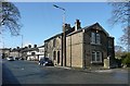
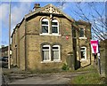
The Old Lodge, Keighley Road, Ovenden
The Old Lodge has some nice decorative woodwork in the gable, perhaps influenced by the Arts and Crafts movement at the end of the 19C. Beyond, in SE0728, the Queen on the inn sign of the Queen's head is Elizabeth I.
Image: © Humphrey Bolton
Taken: 26 Mar 2009
0.04 miles
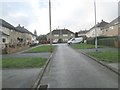
3
Driveway to The Grange - Keighley Road, Illingworth
Image: © Betty Longbottom
Taken: 14 Nov 2007
0.05 miles
4
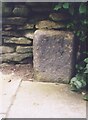
Old milestone
On the east side of the A629 Keighley Road in Ovenden. This stone may date from the early 19C. The Keighley and Halifax turnpike was first enacted in 1819. It is against the wall which surrounds playing fields. Any trace of an inscription has eroded away.
Image: © Robert Glover
Taken: 21 Nov 2020
0.05 miles
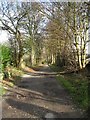
5
The Old Lodge - Keighley Road, Illingworth
This was possibly the lodge to the nearby Grange.
Image: © Betty Longbottom
Taken: 14 Nov 2007
0.05 miles
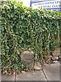
6
Old Milestone, on the A629, Keighley Road, Ovenden
Located on the East side of road, in pavement, back to wall round playing fields nr LP28. Carved stone post, erected by Keighley & Halifax turnpike trust, 19th century. Alternative view see http://www.geograph.org.uk/photo/6741483
Inscription reads: eroded // To / HB… /or HP? // eroded
Milestone Society National ID: YW_KEHA10
Image: © Christine Minto
Taken: 31 Dec 2005
0.05 miles
9
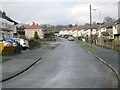
Myrtle Drive - viewed from Myrtle Place
Image: © Betty Longbottom
Taken: 13 Jan 2014
0.06 miles
10
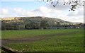
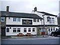
Illingworth Sports Club - Football Pitch - Keighley Road
Image: © Betty Longbottom
Taken: 14 Nov 2007
0.07 miles