IMAGES TAKEN NEAR TO
Burnley Road, HALIFAX, HX2 7LW
Introduction
This page details the photographs taken nearby to Burnley Road, HX2 7LW by members of the Geograph project.
The Geograph project started in 2005 with the aim of publishing, organising and preserving representative images for every square kilometre of Great Britain, Ireland and the Isle of Man.

There are currently over 7.5m images from over14,400 individuals and you can help contribute to the project by visiting https://www.geograph.org.uk
Image Map
Images are licensed for reuse under creativecommons.org/licenses/by-sa/2.0
Notes
- Clicking on the map will re-center to the selected point.
- The higher the marker number, the further away the image location is from the centre of the postcode.
Image Listing (104 Images Found)
Images are licensed for reuse under creativecommons.org/licenses/by-sa/2.0
Image
Details
Distance
1
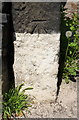
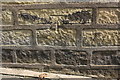
Benchmark on gatepost at entrance to #434 Burnley Road
Ordnance Survey cut mark benchmark levelled at 194.761m above Newlyn Datum
Image: © Roger Templeman
Taken: 23 May 2018
0.02 miles
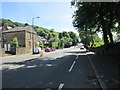
2
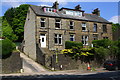
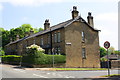
Burnley Road houses at junction with side road
There is an OS benchmark Image on the gatepost on the wall corner on the nearside of the access steps to #434
Image: © Roger Templeman
Taken: 23 May 2018
0.02 miles
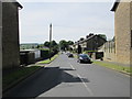
3
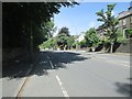
Burnley Road - viewed from Willowfield Close
Image: © Betty Longbottom
Taken: 6 Jun 2014
0.03 miles
5
Benchmark on #457 Burnley Road (Willow Drive face)
Ordnance Survey cut mark benchmark levelled at 193.579m above Newlyn Datum
Image: © Roger Templeman
Taken: 23 May 2018
0.04 miles
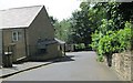
6
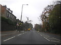
Burnley Road houses at Willow Drive junction
There is an OS benchmark Image on the Willow Drive face of the nearest house about 12 feet from its near corner
Image: © Roger Templeman
Taken: 23 May 2018
0.04 miles
9

Old Milestone by the A646, Skircoat, Halifax
Carved stone post by the A646, in parish of HALIFAX (CALDERDALE District), Skircoat, opposite Willow Drive; by No. 448, by the road, on North side of road. Todmorden rolltop, erected by the Todmorden turnpike trust in the 18th/19th century.
Inscription reads:- : TO / TODMORDEN / {hand} 10 MILES / TO / HALIFAX / 1¾ {hand} / SKIRCOAT :
Milestone Society National ID: YW_TOHA10.
Image: © C Minto
Taken: 1 Dec 2002
0.05 miles
10
Burnley Road - viewed from Willowfield Close
Image: © Betty Longbottom
Taken: 6 Jun 2014
0.05 miles