IMAGES TAKEN NEAR TO
Willowfield Terrace, HALIFAX, HX2 7JL
Introduction
This page details the photographs taken nearby to Willowfield Terrace, HX2 7JL by members of the Geograph project.
The Geograph project started in 2005 with the aim of publishing, organising and preserving representative images for every square kilometre of Great Britain, Ireland and the Isle of Man.

There are currently over 7.5m images from over14,400 individuals and you can help contribute to the project by visiting https://www.geograph.org.uk
Image Map
Images are licensed for reuse under creativecommons.org/licenses/by-sa/2.0
Notes
- Clicking on the map will re-center to the selected point.
- The higher the marker number, the further away the image location is from the centre of the postcode.
Image Listing (107 Images Found)
Images are licensed for reuse under creativecommons.org/licenses/by-sa/2.0
Image
Details
Distance
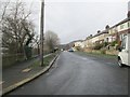
1
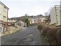
Willowfield Terrace - Willowfield Road
Image: © Betty Longbottom
Taken: 6 Jan 2014
0.03 miles
2
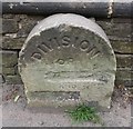
Old Boundary Marker by the A646, Burnley Road, Halifax Parish
Parish Boundary Marker by the A646, in parish of Halifax (Calderdale District), Burnley Road close to junction with Green Lane, against stone wall.
To be surveyed
Milestone Society National ID: YW_SOWB04pb
Image: © Roger Templeman
Taken: Unknown
0.04 miles
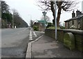
3
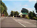
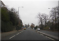
Burnley Road (A646), Halifax
At the junction with Green Lane.
Image: © David Dixon
Taken: 3 Sep 2010
0.04 miles
4
Defaced boundary stone beside Burnley Road
Image: © Roger Templeman
Taken: 29 May 2018
0.05 miles
6
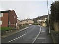
Willowfield Crescent - Willowfield Road
Image: © Betty Longbottom
Taken: 6 Jan 2014
0.05 miles
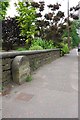
7
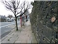
Boundary stone, Burnley Road
This was on the boundary between Halifax and Skircoat. The place names have been chiselled away. See Image for a close view.
Image: © Humphrey Bolton
Taken: 12 Feb 2013
0.05 miles
8
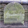
Boundary stone, Burnley Road
This was on the boundary between Halifax and Skircoat. Skircoat Civil Parish had been administered by the Sowerby Bridge local board and Halifax borough since the mid-19C, and in 1894 these parts became fully integrated into Sowerby Bridge UDC and Halifax County Borough. The remaining area was a small civil parish in Halifax RDC (Rural District Council). In 1899 this too was transferred to Halifax. That might have been when the names were chiselled from the stone.
Image: © Humphrey Bolton
Taken: 12 Feb 2013
0.05 miles
10
Old water main valve marker plate, Burnley Road
See Image for a close view.
Image: © Humphrey Bolton
Taken: 12 Feb 2013
0.06 miles