IMAGES TAKEN NEAR TO
Gainest, HALIFAX, HX2 7DT
Introduction
This page details the photographs taken nearby to Gainest, HX2 7DT by members of the Geograph project.
The Geograph project started in 2005 with the aim of publishing, organising and preserving representative images for every square kilometre of Great Britain, Ireland and the Isle of Man.

There are currently over 7.5m images from over14,400 individuals and you can help contribute to the project by visiting https://www.geograph.org.uk
Image Map
Images are licensed for reuse under creativecommons.org/licenses/by-sa/2.0
Notes
- Clicking on the map will re-center to the selected point.
- The higher the marker number, the further away the image location is from the centre of the postcode.
Image Listing (224 Images Found)
Images are licensed for reuse under creativecommons.org/licenses/by-sa/2.0
Image
Details
Distance
2
Closed water tunnels behind property in Upper Washer Lane
These are two of the water tunnels constructed by John Edward Wainhouse to gather water for his Dye Works on the site of what is now the Washer Lane Industrial Estate. Situated behind private houses, they seem now to be used for garden storage.
Image: © Michael Steele
Taken: 2 Feb 2014
0.03 miles
3

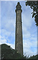
Wainhouse Waiting
Open evening at Wainhouse Tower.
Image: © Ivan Hall
Taken: 12 Sep 2009
0.04 miles
5
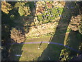
Lawn at the Base of Wainhouse Tower
My camera was braver than I was here.
Image: © Ivan Hall
Taken: 12 Sep 2009
0.04 miles
6

Aqueduct over the road to Washer Lane Dyeworks
This carried spring water to feed a millpond, now filled in.
Image: © Humphrey Bolton
Taken: 11 Dec 2012
0.05 miles
8
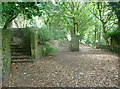
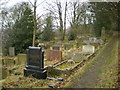
Footpaths and an entrance to King Cross Cemetery, Skircoat
King Cross Cemetery has grown over the years. There is a vehicle entrance to whatv is probably the oldest part of it on the right. The part on the left is also old but was originally the burial ground for a Methodist chapel. Halifax FP670 is straight on, originally a field path but widened and enclosed when the cemetery was extended eastwards. The steps on the left are on FP668, a short path leading to Skicoat Moor Road.
Image: © Humphrey Bolton
Taken: 2 Aug 2018
0.06 miles
9

Properties in Gainest, taken from Upper Washer Lane
Image: © Michael Steele
Taken: 2 Feb 2014
0.06 miles
10
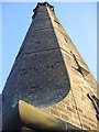
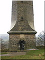
Wainhouse Tower, Halifax
Probably the most ornate factory chimney in the land, the Wainhouse Tower is certainly the tallest folly. A prominent local landmark. Check out: http://www.heritage.co.uk/follies/ffwy09.html
Image: © Ian M
Taken: 6 Aug 2005
0.06 miles