IMAGES TAKEN NEAR TO
Darcey Hey Lane, HALIFAX, HX2 7DD
Introduction
This page details the photographs taken nearby to Darcey Hey Lane, HX2 7DD by members of the Geograph project.
The Geograph project started in 2005 with the aim of publishing, organising and preserving representative images for every square kilometre of Great Britain, Ireland and the Isle of Man.

There are currently over 7.5m images from over14,400 individuals and you can help contribute to the project by visiting https://www.geograph.org.uk
Image Map (Loading...)


Getting Data...Please wait
Leaflet Map data © OpenStreetMap
Images are licensed for reuse under creativecommons.org/licenses/by-sa/2.0
Notes
- Clicking on the map will re-center to the selected point.
- The higher the marker number, the further away the image location is from the centre of the postcode.
Image Listing (214 Images Found)
Images are licensed for reuse under creativecommons.org/licenses/by-sa/2.0
Image
Details
Distance
1
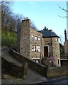
Award winning House in Darcey Hey Lane
This distinctive property proudly displays a 'green plaque' issued by Halifax Civic Trust in 1999, when it featured in their annual awards.
Image: © Michael Steele
Taken: 2 Feb 2014
0.01 miles
2

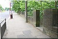
Junction of lane from Darcey Hey Lane
There is an OS benchmark Image on the left hand gatepost at the lane entrance
Image: © Roger Templeman
Taken: 29 May 2018
0.02 miles
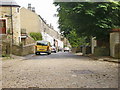
4
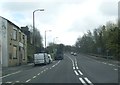
A58 Rochdale Road at the closed Wellington Inn
Image: © Colin Pyle
Taken: 26 Apr 2018
0.02 miles
5

Benchmark on stone post at road junction on Darcey Hey Lane
Ordnance Survey cut mark benchmark levelled at 172.715m above Newlyn Datum
Image: © Roger Templeman
Taken: 29 May 2018
0.02 miles
6
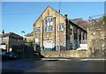
The former St Paul?s Mission Room, Edwards Road
Now a nursery school. The building is on the 1:2500 map of c.1920 but not on the 1907 edition. It is St Paul's on the map, but in the diocese records it is St James's Mission; it closed for worship in 1992. St Paul's Church at King Cross was captioned 'St Paul's Old Church' on the 1920 map and had been demolished apart from the belfry on the 1933 map. Perhaps the mission room replaced it.
The housing estate was built on the other sort of nursery!
Image: © Humphrey Bolton
Taken: 11 Dec 2012
0.03 miles
7
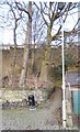
Entrance to descending steps from Rochdale Road
There is an OS benchmark Image on the near wall pier
Image: © Roger Templeman
Taken: 29 May 2018
0.03 miles
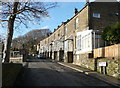
10
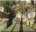
Footpath from Darcey Hey Lane to Rochdale Road
This section of footpath, surfaced in stone setts, joins a flight of steps to join Rochdale Road. The steps were, clearly, constructed as part of a road widening scheme. The old footpath re-emerges across Rochdale Road, and reaches Burnley Road up an old flight of steps, before continuing up the hillside towards Warley Road.
Image: © Michael Steele
Taken: 2 Feb 2014
0.04 miles