IMAGES TAKEN NEAR TO
Luddenden, HALIFAX, HX2 6TW
Introduction
This page details the photographs taken nearby to HX2 6TW by members of the Geograph project.
The Geograph project started in 2005 with the aim of publishing, organising and preserving representative images for every square kilometre of Great Britain, Ireland and the Isle of Man.

There are currently over 7.5m images from over14,400 individuals and you can help contribute to the project by visiting https://www.geograph.org.uk
Image Map (Loading...)


Getting Data...Please wait
Leaflet Map data © OpenStreetMap
Images are licensed for reuse under creativecommons.org/licenses/by-sa/2.0
Notes
- Clicking on the map will re-center to the selected point.
- The higher the marker number, the further away the image location is from the centre of the postcode.
Image Listing (53 Images Found)
Images are licensed for reuse under creativecommons.org/licenses/by-sa/2.0
Image
Details
Distance
1
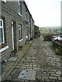
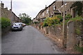
Sowerby Bridge Bridleway 4 passing Far Broad Fold
This bridleway comes up from Jerusalem Lane and is captioned 'Bridle Road' on the 1860 six-inch map.
Image: © Humphrey Bolton
Taken: 19 Feb 2017
0.09 miles
2
Sowerby Bridge FP4 (W7) passing a tree house
Image: © Humphrey Bolton
Taken: 19 Feb 2017
0.11 miles
3
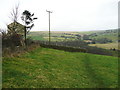
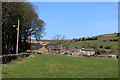
Luddenden Dean (3)
From the slopes below High House, looking east towards Booth.
Image: © John Topping
Taken: 25 Sep 2009
0.13 miles
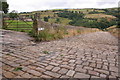
4
Sowerby Bridge FP4 (W6)
This view is approaching the stile shown in Image
Image: © Humphrey Bolton
Taken: 19 Feb 2017
0.13 miles
6
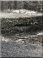
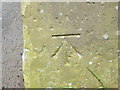
Potential OSBM
Likely to be the remains of an Ordnance Survey benchmark.
Image: © Eliot Dales
Taken: 22 Jun 2020
0.13 miles
7
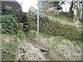
Steps up from Sowerby Bridge Bridleway 4 to High House Lane
These lead across the lane to FP7.
Image: © Humphrey Bolton
Taken: 19 Feb 2017
0.14 miles
8
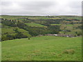
Cow Lane, Booth
Looking NE along Cow Lane as it descends into Luddenden Dean. The village of Booth can be seen through the bars of the gate.
Image: © Mark Anderson
Taken: 5 Aug 2005
0.14 miles
9
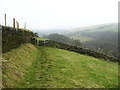
Booth
Looking towards the community of Booth from Cow Lane, in Luddenden Dean
Image: © Chris Heaton
Taken: 22 Feb 2019
0.14 miles
10
Ordnance Survey Cut Mark
This mark can be found on a stone gatepost in Thornley Lane near Midgley. The benchmark height is recorded as being 245.5774 metres above sea level.
For more detail see : http://www.bench-marks.org.uk/bm30272
Image: © Peter Wood
Taken: 27 Apr 2017
0.15 miles