IMAGES TAKEN NEAR TO
Midgley, Luddendenfoot, HALIFAX, HX2 6TS
Introduction
This page details the photographs taken nearby to HX2 6TS by members of the Geograph project.
The Geograph project started in 2005 with the aim of publishing, organising and preserving representative images for every square kilometre of Great Britain, Ireland and the Isle of Man.

There are currently over 7.5m images from over14,400 individuals and you can help contribute to the project by visiting https://www.geograph.org.uk
Image Map
Images are licensed for reuse under creativecommons.org/licenses/by-sa/2.0
Notes
- Clicking on the map will re-center to the selected point.
- The higher the marker number, the further away the image location is from the centre of the postcode.
Image Listing (74 Images Found)
Images are licensed for reuse under creativecommons.org/licenses/by-sa/2.0
Image
Details
Distance
1
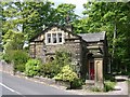
Lodge to The Greaves - Solomon Hill, Midgley
Image: © Betty Longbottom
Taken: 20 May 2008
0.01 miles
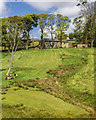
2

Small reservoir, Rails Lane, Luddenden
Just above the road, and perhaps a mill-pond.
Image: © Humphrey Bolton
Taken: 23 Oct 2008
0.07 miles
3
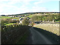
Green Lane, Midgley
This is Sowerby Bridge Bridleway 28.
Image: © Humphrey Bolton
Taken: 3 Nov 2014
0.09 miles
4
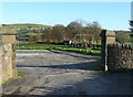
Entrance to the John Murgatroyd Recreation Ground
This was presented to the Township of Midgley according to the wishes of the late John Murgatroyd of Broadfold, Midgley, 1st August 1925.
Image: © Humphrey Bolton
Taken: 3 Nov 2014
0.10 miles
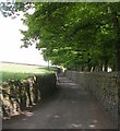
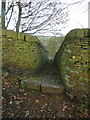
5
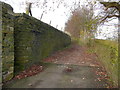
Pin Hill Lane, Midgley
This is Sowerby Bridge Bridleway 25, where the tarmac surface ends. The opening on the left is FP17, which goes up a flight of steps showing that the wall on the left is a retaining wall.
Image: © Humphrey Bolton
Taken: 10 Nov 2014
0.11 miles
6
Pin Hill Lane
House on Pin Hill Lane.
Image: © Peter McDermott
Taken: 14 May 2016
0.11 miles
8
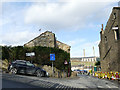
South end of Duke Street, Luddenden
The houses on the left are listed grade II (List entry 1134538).
Image: © Stephen Craven
Taken: 16 Feb 2019
0.12 miles
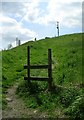
10
Sowerby Bridge FP26 at Pin Hill Lane
This footpath is shown as an unenclosed field path on the 1850 six-inch map. It was walled by the time of the 1894 1:2500 map. There was a house called Croft Top to the right.
Image: © Humphrey Bolton
Taken: 10 Nov 2014
0.12 miles