IMAGES TAKEN NEAR TO
Booth House Road, HALIFAX, HX2 6HJ
Introduction
This page details the photographs taken nearby to Booth House Road, HX2 6HJ by members of the Geograph project.
The Geograph project started in 2005 with the aim of publishing, organising and preserving representative images for every square kilometre of Great Britain, Ireland and the Isle of Man.

There are currently over 7.5m images from over14,400 individuals and you can help contribute to the project by visiting https://www.geograph.org.uk
Image Map
Images are licensed for reuse under creativecommons.org/licenses/by-sa/2.0
Notes
- Clicking on the map will re-center to the selected point.
- The higher the marker number, the further away the image location is from the centre of the postcode.
Image Listing (103 Images Found)
Images are licensed for reuse under creativecommons.org/licenses/by-sa/2.0
Image
Details
Distance
2
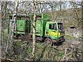
Disused lorry in council yard, Luddendenfoot
This was perhaps one of the first generation of lorries adapted for the kerbside collection of recyclable materials.
Image: © Humphrey Bolton
Taken: 1 Apr 2012
0.04 miles
3
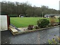
Luddendenfoot Bowling Club
At Tillotson Holme, between the Rochdale Canal and the River Calder.
Image: © Christine Johnstone
Taken: 8 Dec 2020
0.08 miles
4
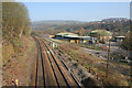
Railway, Luddendenfoot
Looking north-west from Blackwood Hall Lane bridge. This view includes land that was the site of Luddendenfoot Railway Station. Branwell Bronte worked here as Clerk in Charge but was dismissed after a year due to a deficit in the accounts. On the hillside to the right is the Kershaw estate and on the far hillside is Midgley.
Image: © Mark Anderson
Taken: 2 Apr 2007
0.09 miles
5
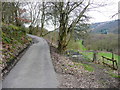
Hand Carr Lane, Luddendenfoot
The footpath to Blind Lane starts on the right.
Image: © Humphrey Bolton
Taken: 29 Feb 2016
0.10 miles
6
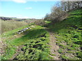
Footpath in the old lane to Hand Carr Mill, Luddendenfoot
Image: © Humphrey Bolton
Taken: 17 Apr 2016
0.13 miles
8
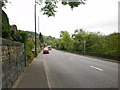
Burnley Road A646, Luddenden Foot
This road was constructed c. 1760. Before that traffic had to climb up to Midgley before descending again to Hebden bridge.
Image: © Humphrey Bolton
Taken: 16 Oct 2008
0.14 miles
9
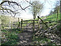
Footpath gate near the ruins of Hand Carr Mill, Luddendenfoot
Image: © Humphrey Bolton
Taken: 17 Apr 2016
0.14 miles
10
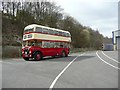
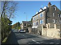
Old bus at Luddenden Foot
The Sustrans Cycle Route 66 goes through the yard of a bus hire company.
Image: © Humphrey Bolton
Taken: 23 Apr 2013
0.14 miles