IMAGES TAKEN NEAR TO
Blackwood Hall Lane, HALIFAX, HX2 6HD
Introduction
This page details the photographs taken nearby to Blackwood Hall Lane, HX2 6HD by members of the Geograph project.
The Geograph project started in 2005 with the aim of publishing, organising and preserving representative images for every square kilometre of Great Britain, Ireland and the Isle of Man.

There are currently over 7.5m images from over14,400 individuals and you can help contribute to the project by visiting https://www.geograph.org.uk
Image Map
Images are licensed for reuse under creativecommons.org/licenses/by-sa/2.0
Notes
- Clicking on the map will re-center to the selected point.
- The higher the marker number, the further away the image location is from the centre of the postcode.
Image Listing (119 Images Found)
Images are licensed for reuse under creativecommons.org/licenses/by-sa/2.0
Image
Details
Distance
2
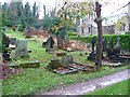
Graveyard of the former St Mary?s Church, Luddendenfoot
This part of the graveyard is still cared for, with floral tributes on some of the graves. The house is on the site of St Mary’s Church, which was built between 1850 and 1895 (from OS maps) and demolished in the 1970s. Amazingly, it is still shown on the 1:25000 map!
Image: © Humphrey Bolton
Taken: 26 Nov 2012
0.03 miles
3
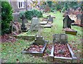
Graveyard of the former St Mary?s Church, Luddendenfoot
See also Image The building on the left is the former church school, converted to houses.
Image: © Humphrey Bolton
Taken: 26 Nov 2012
0.03 miles

6

Bay Mill Lane - Station Road, Luddenden Foot
Image: © Betty Longbottom
Taken: 20 May 2008
0.07 miles
7
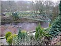
Pipe bridge over the River Calder, Luddenden Foot
A lattice-girder construction. The park is in the distance.
Image: © Humphrey Bolton
Taken: 19 Feb 2009
0.07 miles
8

Road bridge over the River Calder, Luddenden Foot
This looks like an iron arch, or at least it is rust-coloured. The road is Station Road.
Image: © Humphrey Bolton
Taken: 19 Feb 2009
0.07 miles
9
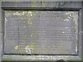
Plaque on Boy Bridge, Station Road, Luddenden Foot
This records that the bridge was erected by the Luddenden Foot Board of Health in 1882, and lists every member of the board at that time and their clerk, also the engineer, the mason, the ironfounders, and in small letters at the bottom the 'sculptor' who made the plaque, J Moses of Hebden Bridge. There was a bridge here in 1850, narrower and crossing at a different angle.
Image: © Humphrey Bolton
Taken: 27 Feb 2009
0.07 miles
10
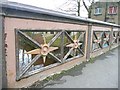
Parapet of Boy Bridge, Station Road, Luddenden Foot
This is decorative, but with a pattern that makes it difficult for small children to get through.
Image: © Humphrey Bolton
Taken: 27 Feb 2009
0.07 miles