IMAGES TAKEN NEAR TO
Ripley Terrace, HALIFAX, HX2 6AN
Introduction
This page details the photographs taken nearby to Ripley Terrace, HX2 6AN by members of the Geograph project.
The Geograph project started in 2005 with the aim of publishing, organising and preserving representative images for every square kilometre of Great Britain, Ireland and the Isle of Man.

There are currently over 7.5m images from over14,400 individuals and you can help contribute to the project by visiting https://www.geograph.org.uk
Image Map
Images are licensed for reuse under creativecommons.org/licenses/by-sa/2.0
Notes
- Clicking on the map will re-center to the selected point.
- The higher the marker number, the further away the image location is from the centre of the postcode.
Image Listing (134 Images Found)
Images are licensed for reuse under creativecommons.org/licenses/by-sa/2.0
Image
Details
Distance
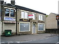
3
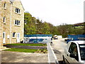
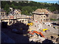
New development at Luddenden Foot
On a former mill site
Image: © Alexander P Kapp
Taken: 22 Apr 2009
0.04 miles
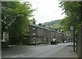
7
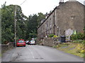
Weaver's Arms - Burnley Road, Luddenden Foot
Image: © Betty Longbottom
Taken: 20 May 2008
0.07 miles
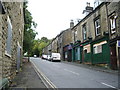
8
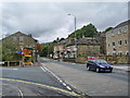
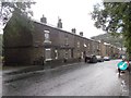
Burnley Road at the junction with Station Road
Image: © Alexander P Kapp
Taken: 15 Oct 2008
0.07 miles
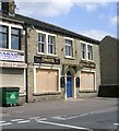
9
Building houses, Luddendenfoot
Looking SW. These houses are being built on the site of an old mill.
Image: © Mark Anderson
Taken: 27 Jun 2005
0.07 miles