IMAGES TAKEN NEAR TO
Prospect Place, HALIFAX, HX2 0UW
Introduction
This page details the photographs taken nearby to Prospect Place, HX2 0UW by members of the Geograph project.
The Geograph project started in 2005 with the aim of publishing, organising and preserving representative images for every square kilometre of Great Britain, Ireland and the Isle of Man.

There are currently over 7.5m images from over14,400 individuals and you can help contribute to the project by visiting https://www.geograph.org.uk
Image Map
Images are licensed for reuse under creativecommons.org/licenses/by-sa/2.0
Notes
- Clicking on the map will re-center to the selected point.
- The higher the marker number, the further away the image location is from the centre of the postcode.
Image Listing (66 Images Found)
Images are licensed for reuse under creativecommons.org/licenses/by-sa/2.0
Image
Details
Distance
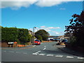
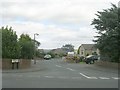
2
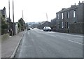
Mount Tabor Road - viewed from Waindale Crescent
Image: © Betty Longbottom
Taken: 9 Feb 2015
0.02 miles
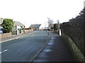
3
Waindale Close, Mount Tabor, near Halifax
Waindale Close is a short residential cul-de-sac in the village of Mount Tabor, near Halifax.
Image: © Malc McDonald
Taken: 29 Aug 2016
0.02 miles
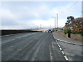
4
Waindale Crescent - Mount Tabor Road
Image: © Betty Longbottom
Taken: 9 Feb 2015
0.04 miles
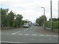
5
Mount Tabor Road - viewed from Waindale Crescent
Image: © Betty Longbottom
Taken: 9 Feb 2015
0.04 miles
6
Waindale Crescent - Mount Tabor Road
Image: © Betty Longbottom
Taken: 30 Aug 2010
0.04 miles
8
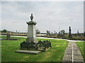
Mount Tabor Methodist Church, Graveyard
Image: © Alexander P Kapp
Taken: 25 Sep 2008
0.05 miles