IMAGES TAKEN NEAR TO
Ovenden Wood, HALIFAX, HX2 0TR
Introduction
This page details the photographs taken nearby to HX2 0TR by members of the Geograph project.
The Geograph project started in 2005 with the aim of publishing, organising and preserving representative images for every square kilometre of Great Britain, Ireland and the Isle of Man.

There are currently over 7.5m images from over14,400 individuals and you can help contribute to the project by visiting https://www.geograph.org.uk
Image Map
Images are licensed for reuse under creativecommons.org/licenses/by-sa/2.0
Notes
- Clicking on the map will re-center to the selected point.
- The higher the marker number, the further away the image location is from the centre of the postcode.
Image Listing (24 Images Found)
Images are licensed for reuse under creativecommons.org/licenses/by-sa/2.0
Image
Details
Distance
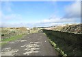
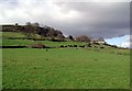
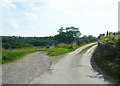
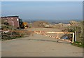
2
Halifax Bridleway 257 approaching Brown Hurst
Image: © Humphrey Bolton
Taken: 19 Jun 2017
0.04 miles
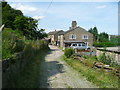
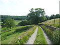
3
Lower Brown Hurst, Ovenden Wood
Farm perched on the hillside between Delf Hill Quarries and Hebble Brook, south of Mixenden.
Image: © Paul Glazzard
Taken: 26 Feb 2007
0.08 miles
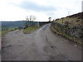
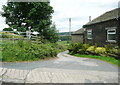
4
Junction of Halifax Bridleways 257 and 275
Image: © Humphrey Bolton
Taken: 19 Jun 2017
0.10 miles
7
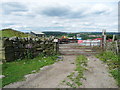
'Keep Out' sign on Halifax Bridleway 271
Image: © Humphrey Bolton
Taken: 26 Jun 2017
0.16 miles
8
Entrance to quarry, Gibb Lane, Ovenden
This is Sunny Bank Quarry, on the 1850 map and still in operation.
Image: © Humphrey Bolton
Taken: 20 Mar 2009
0.17 miles
9
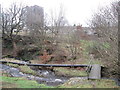
Footbridge over Hebble Brook, Illingworth
Image: © John Slater
Taken: 26 Jan 2015
0.18 miles