IMAGES TAKEN NEAR TO
Lower Brown Hurst, HALIFAX, HX2 0TP
Introduction
This page details the photographs taken nearby to Lower Brown Hurst, HX2 0TP by members of the Geograph project.
The Geograph project started in 2005 with the aim of publishing, organising and preserving representative images for every square kilometre of Great Britain, Ireland and the Isle of Man.

There are currently over 7.5m images from over14,400 individuals and you can help contribute to the project by visiting https://www.geograph.org.uk
Image Map (Loading...)


Getting Data...Please wait
Leaflet Map data © OpenStreetMap
Images are licensed for reuse under creativecommons.org/licenses/by-sa/2.0
Notes
- Clicking on the map will re-center to the selected point.
- The higher the marker number, the further away the image location is from the centre of the postcode.
Image Listing (29 Images Found)
Images are licensed for reuse under creativecommons.org/licenses/by-sa/2.0
Image
Details
Distance
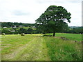
1
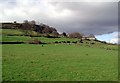
Lower Brown Hurst, Ovenden Wood
Farm perched on the hillside between Delf Hill Quarries and Hebble Brook, south of Mixenden.
Image: © Paul Glazzard
Taken: 26 Feb 2007
0.02 miles
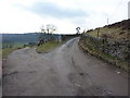
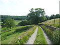
3
Halifax Bridleway 257 approaching Brown Hurst
Image: © Humphrey Bolton
Taken: 19 Jun 2017
0.05 miles
4
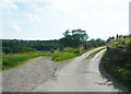
Junction of Halifax Bridleways 257 and 275
Image: © Humphrey Bolton
Taken: 19 Jun 2017
0.07 miles
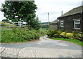
6
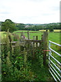
Stile on Halifax FP286 at the junction with FP283
The gate across FP283, to the right, is tied with twine. However you can go over the stile and then turn right.
Image: © Humphrey Bolton
Taken: 26 Jun 2017
0.13 miles
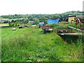
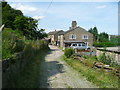
10
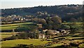
Riding & Gibralter Farms
View over the farms to Broadley housing on the skyline and the new development at Fountainhead to the left
Image: © Kevin Waterhouse
Taken: 7 Mar 2010
0.18 miles