IMAGES TAKEN NEAR TO
Moor End Road, HALIFAX, HX2 0SF
Introduction
This page details the photographs taken nearby to Moor End Road, HX2 0SF by members of the Geograph project.
The Geograph project started in 2005 with the aim of publishing, organising and preserving representative images for every square kilometre of Great Britain, Ireland and the Isle of Man.

There are currently over 7.5m images from over14,400 individuals and you can help contribute to the project by visiting https://www.geograph.org.uk
Image Map
Images are licensed for reuse under creativecommons.org/licenses/by-sa/2.0
Notes
- Clicking on the map will re-center to the selected point.
- The higher the marker number, the further away the image location is from the centre of the postcode.
Image Listing (54 Images Found)
Images are licensed for reuse under creativecommons.org/licenses/by-sa/2.0
Image
Details
Distance
1
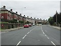
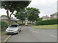
Moor End Road - viewed from Ashville Gardens
Image: © Betty Longbottom
Taken: 16 Jun 2014
0.02 miles
2

Grocers & Off Licence - Moor End Road
Image: © Betty Longbottom
Taken: 26 Jun 2014
0.02 miles
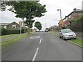
5

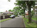
Moor End Road - viewed from Ashville Gardens
Image: © Betty Longbottom
Taken: 16 Jun 2014
0.04 miles
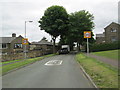
8

Moor End Road - viewed from Grisedale Close
Image: © Betty Longbottom
Taken: 26 Jun 2014
0.10 miles
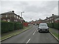
10
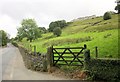
Hillside above Ovenden Wood Road
From by the trees on the left of Image], looking back up the hillside to houses on Grisedale Close.
Image: © Derek Harper
Taken: 3 Jul 2014
0.10 miles