IMAGES TAKEN NEAR TO
Rushton Hill Close, HALIFAX, HX2 0QT
Introduction
This page details the photographs taken nearby to Rushton Hill Close, HX2 0QT by members of the Geograph project.
The Geograph project started in 2005 with the aim of publishing, organising and preserving representative images for every square kilometre of Great Britain, Ireland and the Isle of Man.

There are currently over 7.5m images from over14,400 individuals and you can help contribute to the project by visiting https://www.geograph.org.uk
Image Map
Images are licensed for reuse under creativecommons.org/licenses/by-sa/2.0
Notes
- Clicking on the map will re-center to the selected point.
- The higher the marker number, the further away the image location is from the centre of the postcode.
Image Listing (53 Images Found)
Images are licensed for reuse under creativecommons.org/licenses/by-sa/2.0
Image
Details
Distance
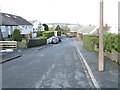
1

Rushton Hill Close - looking towards Rye Lane
Image: © Betty Longbottom
Taken: 26 Jun 2014
0.02 miles
2

Silverwood Walk - viewed from Rushton Hill Close
Image: © Betty Longbottom
Taken: 26 Jun 2014
0.02 miles

4
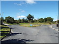
Bus turning circle, Rye Lane, Halifax
This turning circle is provided for buses terminating at the end of Rye Lane.
Image: © Malc McDonald
Taken: 29 Aug 2016
0.07 miles
5

Bus Turning Circle - with bus! - Rye Lane
Image: © Betty Longbottom
Taken: 26 Jun 2014
0.07 miles
6
Broadley Grove - looking towards Moor End Road
Image: © Betty Longbottom
Taken: 9 Feb 2015
0.07 miles
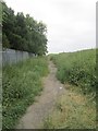
7
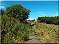
Path near Rye Lane, Halifax
A footpath on the outskirts of Halifax, in West Yorkshire.
Image: © Malc McDonald
Taken: 29 Aug 2016
0.08 miles