IMAGES TAKEN NEAR TO
Vicar Park Road, HALIFAX, HX2 0NL
Introduction
This page details the photographs taken nearby to Vicar Park Road, HX2 0NL by members of the Geograph project.
The Geograph project started in 2005 with the aim of publishing, organising and preserving representative images for every square kilometre of Great Britain, Ireland and the Isle of Man.

There are currently over 7.5m images from over14,400 individuals and you can help contribute to the project by visiting https://www.geograph.org.uk
Image Map (Loading...)


Getting Data...Please wait
Leaflet Map data © OpenStreetMap
Images are licensed for reuse under creativecommons.org/licenses/by-sa/2.0
Notes
- Clicking on the map will re-center to the selected point.
- The higher the marker number, the further away the image location is from the centre of the postcode.
Image Listing (75 Images Found)
Images are licensed for reuse under creativecommons.org/licenses/by-sa/2.0
Image
Details
Distance
6
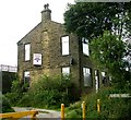
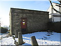
House near Royles Head Reservoir - off Paddock Lane
Image: © Betty Longbottom
Taken: 4 Aug 2008
0.06 miles
9
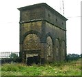
Water tower at the former Roils Head Reservoir - off Paddock Lane
Image: © Betty Longbottom
Taken: 4 Aug 2008
0.08 miles
10
Electricity Substation No 717 - Roils Head Road
Image: © Betty Longbottom
Taken: 3 Feb 2015
0.09 miles