IMAGES TAKEN NEAR TO
Warley Road, HALIFAX, HX2 0BQ
Introduction
This page details the photographs taken nearby to Warley Road, HX2 0BQ by members of the Geograph project.
The Geograph project started in 2005 with the aim of publishing, organising and preserving representative images for every square kilometre of Great Britain, Ireland and the Isle of Man.

There are currently over 7.5m images from over14,400 individuals and you can help contribute to the project by visiting https://www.geograph.org.uk
Image Map
Images are licensed for reuse under creativecommons.org/licenses/by-sa/2.0
Notes
- Clicking on the map will re-center to the selected point.
- The higher the marker number, the further away the image location is from the centre of the postcode.
Image Listing (106 Images Found)
Images are licensed for reuse under creativecommons.org/licenses/by-sa/2.0
Image
Details
Distance
1
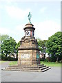
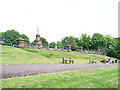
The Soldiers Memorial, West View Park
Unveiled in 1904 to commemorate 73 soldiers killed in the Boer War
Image: © Stanley Walker
Taken: 22 May 2008
0.05 miles
2
Leaving West View Park to join Warley Road, Halifax
Looking north-eastward.
Image: © Peter Wood
Taken: 14 Apr 2018
0.05 miles
3
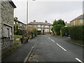
Spring Hall Drive - Spring Hall Lane
Image: © Betty Longbottom
Taken: 6 Jan 2014
0.05 miles
4
West View Crescent - off West View Avenue
Image: © Betty Longbottom
Taken: 20 Jan 2014
0.05 miles
5
The Soldiers Memorial, West View Park
Image: © Stanley Walker
Taken: 22 May 2008
0.05 miles
6
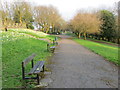
Pathway with seating in West View Park, Halifax
Looking south-eastward.
Image: © Peter Wood
Taken: 14 Apr 2018
0.06 miles
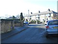
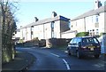
7
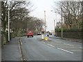
Warley Road - viewed from Spring Hall Lane
Image: © Betty Longbottom
Taken: 6 Jan 2014
0.07 miles
8
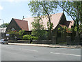
Highroadwell & Warley URC - Warley Road, Halifax
Image: © Betty Longbottom
Taken: 1 Jul 2008
0.08 miles
9
Spring Hall Drive - Spring Hall Lane
Image: © Betty Longbottom
Taken: 20 Jan 2014
0.09 miles
10

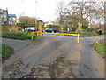
Entrance to former barracks, Gibbet Street, Halifax
This could be called 'Halifax Castle'! It was the barracks of the 33rd Regimental District, according to the 1907 OS map, and is now part of Halifax High School.
Image: © Humphrey Bolton
Taken: 23 Oct 2008
0.09 miles