IMAGES TAKEN NEAR TO
Templars Gate, HALIFAX, HX2 0BP
Introduction
This page details the photographs taken nearby to Templars Gate, HX2 0BP by members of the Geograph project.
The Geograph project started in 2005 with the aim of publishing, organising and preserving representative images for every square kilometre of Great Britain, Ireland and the Isle of Man.

There are currently over 7.5m images from over14,400 individuals and you can help contribute to the project by visiting https://www.geograph.org.uk
Image Map
Images are licensed for reuse under creativecommons.org/licenses/by-sa/2.0
Notes
- Clicking on the map will re-center to the selected point.
- The higher the marker number, the further away the image location is from the centre of the postcode.
Image Listing (55 Images Found)
Images are licensed for reuse under creativecommons.org/licenses/by-sa/2.0
Image
Details
Distance
1
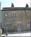
Long Can Hall Hotel - Date stone IMS 1708
Image: © Alan Longbottom
Taken: 28 May 2010
0.02 miles
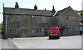
3
Long Can Hall, Ovenden Wood, Halifax
Image: © Humphrey Bolton
Taken: 26 Jun 2017
0.03 miles
4
Ovenden Wood Road at Webster's Brewery
View from Long Can which was preserved, but all other buildings were demolished for new housing. Mount Tabor on the skyline
Image: © Kevin Waterhouse
Taken: 15 Dec 2005
0.05 miles
5
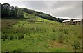
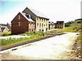
Hillside above Ovenden Wood Road
From the same spot as Image], looking back to the right, with some new houses on Templars Gate. Up above is Ovenden Wood.
Image: © Derek Harper
Taken: 3 Jul 2014
0.06 miles
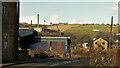
7
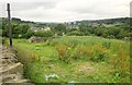
Towards Fountain Head Brewery
From Ovenden Wood Road, looking across fields and an incomplete wall to the slate roofs of the Old Maltings at Fountain Head Brewery, built in 1906 and now offices. "An outstanding example of its type built to a scale that evinces the success of the late C19 brewery trade in this area" http://list.english-heritage.org.uk/resultsingle.aspx?uid=1138779&searchtype=mapsearch . The blocks of flats behind it are at Mixenden, up the Hebble Brook valley.
Image: © Derek Harper
Taken: 3 Jul 2014
0.07 miles
8
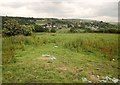
Field beside Ovenden Wood Road
From the same spot as Image], looking across the Hebble Brook valley to Wheatley.
Image: © Derek Harper
Taken: 3 Jul 2014
0.09 miles
9
Ovenden Wood Road
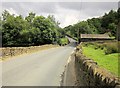
A brief burst of sunshine. Apart from the dip ahead near Yew Trees, the road is climbing towards Pellon.
Image: © Derek Harper
Taken: 3 Jul 2014
0.10 miles
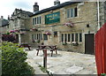
10
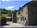
Long Can Hall - Ovenden Wood Road
The building has a date stone showing 1708.
Image: © Betty Longbottom
Taken: 28 May 2010
0.11 miles