IMAGES TAKEN NEAR TO
Crossley Gardens, HALIFAX, HX1 5PU
Introduction
This page details the photographs taken nearby to Crossley Gardens, HX1 5PU by members of the Geograph project.
The Geograph project started in 2005 with the aim of publishing, organising and preserving representative images for every square kilometre of Great Britain, Ireland and the Isle of Man.

There are currently over 7.5m images from over14,400 individuals and you can help contribute to the project by visiting https://www.geograph.org.uk
Image Map (Loading...)


Getting Data...Please wait
Leaflet Map data © OpenStreetMap
Images are licensed for reuse under creativecommons.org/licenses/by-sa/2.0
Notes
- Clicking on the map will re-center to the selected point.
- The higher the marker number, the further away the image location is from the centre of the postcode.
Image Listing (111 Images Found)
Images are licensed for reuse under creativecommons.org/licenses/by-sa/2.0
Image
Details
Distance
3
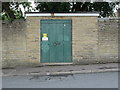
Electricity Substation No 1527 - Hanson Lane
Image: © Betty Longbottom
Taken: 17 Sep 2013
0.05 miles
5
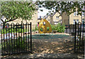
Hanson Lane Memorial Garden
This garden is one of the very few bomb sites in Halifax. The bomb fell on November 22nd 1940 killing 11. Local legends have insisted that a) the bomb was a single one left in a German plane on its way back home after a raid elsewhere or b) the bomb was actually mistakenly dropped by an allied plane.
Image: © Betty Longbottom
Taken: 1 Jul 2008
0.06 miles
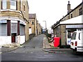
8

Lightowler Close - Lightowler Road
Image: © Betty Longbottom
Taken: 17 Sep 2013
0.08 miles
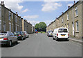
9
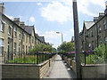
Gladstone Road - Hanson Lane
Gladstone Road was one of a number of streets (running between Hanson Lane and Gibbet Street) which were built in the 1860s as a model planned housing scheme for the workers of local industrialist, John Crossley. Crossley's carpet empire (later the world's largest), was based at Dean Clough Mills, approximately a mile away.
Image: © Betty Longbottom
Taken: 19 Nov 2008
0.08 miles
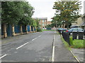
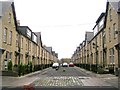
10

St Augustine's Terrace - Hanson Lane
Image: © Betty Longbottom
Taken: 19 Nov 2008
0.09 miles