IMAGES TAKEN NEAR TO
Craven Edge, HALIFAX, HX1 5EG
Introduction
This page details the photographs taken nearby to Craven Edge, HX1 5EG by members of the Geograph project.
The Geograph project started in 2005 with the aim of publishing, organising and preserving representative images for every square kilometre of Great Britain, Ireland and the Isle of Man.

There are currently over 7.5m images from over14,400 individuals and you can help contribute to the project by visiting https://www.geograph.org.uk
Image Map (Loading...)


Getting Data...Please wait
Leaflet Map data © OpenStreetMap
Images are licensed for reuse under creativecommons.org/licenses/by-sa/2.0
Notes
- Clicking on the map will re-center to the selected point.
- The higher the marker number, the further away the image location is from the centre of the postcode.
Image Listing (138 Images Found)
Images are licensed for reuse under creativecommons.org/licenses/by-sa/2.0
Image
Details
Distance
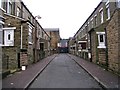
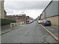
4
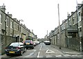
Frank Street - looking towards Hopwood Lane
Image: © Betty Longbottom
Taken: 17 Sep 2013
0.08 miles
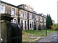
5
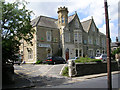
Al-Jamia Al-Zahra - Francis Street
This is an Islamic Educational & Cultural Centre.
Image: © Betty Longbottom
Taken: 1 Jul 2008
0.08 miles
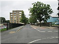
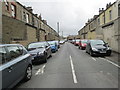
6
Lister Lane - looking towards Hopwood Lane
Image: © Betty Longbottom
Taken: 17 Sep 2013
0.08 miles
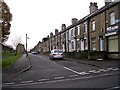
7
Walnut Street - looking towards Hopwood Lane
Image: © Betty Longbottom
Taken: 17 Sep 2013
0.08 miles