IMAGES TAKEN NEAR TO
Grove Street South, HALIFAX, HX1 4LD
Introduction
This page details the photographs taken nearby to Grove Street South, HX1 4LD by members of the Geograph project.
The Geograph project started in 2005 with the aim of publishing, organising and preserving representative images for every square kilometre of Great Britain, Ireland and the Isle of Man.

There are currently over 7.5m images from over14,400 individuals and you can help contribute to the project by visiting https://www.geograph.org.uk
Image Map
Images are licensed for reuse under creativecommons.org/licenses/by-sa/2.0
Notes
- Clicking on the map will re-center to the selected point.
- The higher the marker number, the further away the image location is from the centre of the postcode.
Image Listing (121 Images Found)
Images are licensed for reuse under creativecommons.org/licenses/by-sa/2.0
Image
Details
Distance
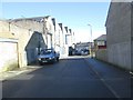
2
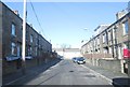
Arundel Street - viewed from Jasper Street
Image: © Betty Longbottom
Taken: 20 Jan 2014
0.03 miles
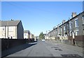
5
Jasper Street - looking towards Queen's Road
Image: © Betty Longbottom
Taken: 20 Jan 2014
0.04 miles
6
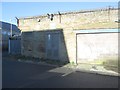
Electricity Substation No B540 - Arundel Street
Image: © Betty Longbottom
Taken: 20 Jan 2014
0.05 miles
7
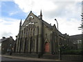
Ukrainian Church, Queen Street, Halifax
Image: © John Slater
Taken: 20 May 2017
0.05 miles
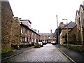
9
Eton Street - looking towards Gibbet Street
Image: © Betty Longbottom
Taken: 20 Jan 2014
0.06 miles
10
Harrow Street - looking towards Gibbet Street
Image: © Betty Longbottom
Taken: 20 Jan 2014
0.07 miles