IMAGES TAKEN NEAR TO
Dunkirk Street, HALIFAX, HX1 3TD
Introduction
This page details the photographs taken nearby to Dunkirk Street, HX1 3TD by members of the Geograph project.
The Geograph project started in 2005 with the aim of publishing, organising and preserving representative images for every square kilometre of Great Britain, Ireland and the Isle of Man.

There are currently over 7.5m images from over14,400 individuals and you can help contribute to the project by visiting https://www.geograph.org.uk
Image Map
Images are licensed for reuse under creativecommons.org/licenses/by-sa/2.0
Notes
- Clicking on the map will re-center to the selected point.
- The higher the marker number, the further away the image location is from the centre of the postcode.
Image Listing (171 Images Found)
Images are licensed for reuse under creativecommons.org/licenses/by-sa/2.0
Image
Details
Distance
3
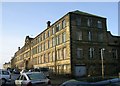
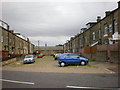
Dunkirk Mills - Dunkirk Lane
Built 1890.
Image: © Betty Longbottom
Taken: 14 Jan 2009
0.03 miles


9

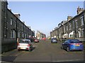
Sun-kissed Sowerby Bridge
The area of King Cross, seen from across the valley in late afternoon.
Image: © John Illingworth
Taken: 1 Nov 2006
0.06 miles
10
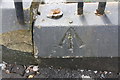
Benchmark on Dunkirk Mills, East Mill wall, Dunkirk Street
Ordnance Survey rivet benchmark levelled at 231.700m above Newlyn Datum
Image: © Roger Templeman
Taken: 29 May 2018
0.06 miles