IMAGES TAKEN NEAR TO
Caygill Terrace, HALIFAX, HX1 2RB
Introduction
This page details the photographs taken nearby to Caygill Terrace, HX1 2RB by members of the Geograph project.
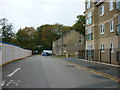
The Geograph project started in 2005 with the aim of publishing, organising and preserving representative images for every square kilometre of Great Britain, Ireland and the Isle of Man.

There are currently over 7.5m images from over14,400 individuals and you can help contribute to the project by visiting https://www.geograph.org.uk
Image Map
Images are licensed for reuse under creativecommons.org/licenses/by-sa/2.0
Notes
- Clicking on the map will re-center to the selected point.
- The higher the marker number, the further away the image location is from the centre of the postcode.
Image Listing (200 Images Found)
Images are licensed for reuse under creativecommons.org/licenses/by-sa/2.0
Image
Details
Distance
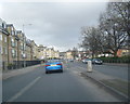
2
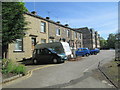
Caygill Terrace - looking towards Skircoat Road
Image: © Betty Longbottom
Taken: 25 May 2013
0.01 miles
3
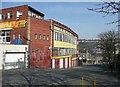
Trinity Garage, Hunger Hill, Halifax
An unusual building. The entrance to the top floor, now a fabric shop, was at the front from Skircoat Road. The middle floor was reached via a ramp from the blocked door on the left, and was the parts department. There was a petrol filling station on the forecourt. The garage sold Rootes Group cars, Hillmans and Humbers.
Image: © Humphrey Bolton
Taken: 20 Mar 2009
0.03 miles
4
Well Head Drive - looking towards Well Head Lane
Image: © Betty Longbottom
Taken: 25 May 2013
0.04 miles
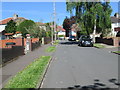
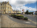
6
Skircoat Road, Halifax
This is a revisit to the first geograph for the square Image], taken in January 2005. The bus lane now has parking places in it and there are parking meters. This is presumably to raise money from the football fans attending matches at The Shay.
Image: © Humphrey Bolton
Taken: 12 Aug 2021
0.06 miles
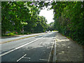
7
Short cycle lane, Oxford Road, Halifax
The purpose of this facility appears to be to allow cyclists to turn left without being caught by other left-turning vehicles.
Image: © Stephen Craven
Taken: 5 Jul 2014
0.06 miles
8
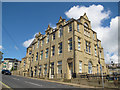
Clare Hall Apartments, Oxford Road, Halifax
Now private housing, this converted school building was formerly part of Clare Hall School, more recently called Halifax High School Image Built 1882, architect Richard Horsfall, and closed as a school in 2004. Listed grade 2 (list entry 1391648). See also Image
Sources: http://www.clarehallapartments.co.uk/history.html and http://list.historicengland.org.uk/resultsingle.aspx?uid=1391648
Image: © Stephen Craven
Taken: 5 Jul 2014
0.07 miles
9
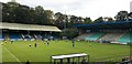
The Shay Stadium, FC Halifax Town
Action in front of the away supporters end at the Shay Stadium, Halifax, home of FC Halifax Town. An FA Cup tie at home to Harrogate Town, Halifax losing 1-2.
Image: © Peter Evans
Taken: 19 Oct 2019
0.09 miles
10
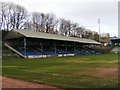
West Stand, the Shay Stadium, Halifax
The southerly part of this Stand was originally at Maine Road, Manchester.
Image: © Michael Steele
Taken: 16 Mar 2009
0.09 miles