IMAGES TAKEN NEAR TO
Clover Hill Close, HALIFAX, HX1 2BS
Introduction
This page details the photographs taken nearby to Clover Hill Close, HX1 2BS by members of the Geograph project.
The Geograph project started in 2005 with the aim of publishing, organising and preserving representative images for every square kilometre of Great Britain, Ireland and the Isle of Man.

There are currently over 7.5m images from over14,400 individuals and you can help contribute to the project by visiting https://www.geograph.org.uk
Image Map
Images are licensed for reuse under creativecommons.org/licenses/by-sa/2.0
Notes
- Clicking on the map will re-center to the selected point.
- The higher the marker number, the further away the image location is from the centre of the postcode.
Image Listing (132 Images Found)
Images are licensed for reuse under creativecommons.org/licenses/by-sa/2.0
Image
Details
Distance
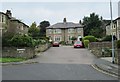
1
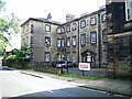
Savile Place, Savile Road
Built in the 18th century for whom and what purpose i have not been able to find but it is a fair sized property and now used for flats.
Image: © Stanley Walker
Taken: 22 Aug 2008
0.02 miles
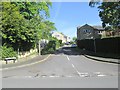
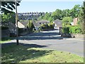
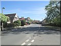
4
Love Lane - viewed from Well Head Lane
Image: © Betty Longbottom
Taken: 25 May 2013
0.03 miles
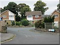
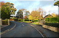
7
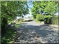
Well Head Lane - viewed from Heath Lea
Image: © Betty Longbottom
Taken: 25 May 2013
0.04 miles
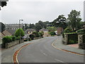
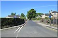
10
Well Head Lane - viewed from Heath Lea
Image: © Betty Longbottom
Taken: 25 May 2013
0.05 miles