IMAGES TAKEN NEAR TO
Shannon Road, HULL, HU8 9SD
Introduction
This page details the photographs taken nearby to Shannon Road, HU8 9SD by members of the Geograph project.
The Geograph project started in 2005 with the aim of publishing, organising and preserving representative images for every square kilometre of Great Britain, Ireland and the Isle of Man.

There are currently over 7.5m images from over14,400 individuals and you can help contribute to the project by visiting https://www.geograph.org.uk
Image Map
Images are licensed for reuse under creativecommons.org/licenses/by-sa/2.0
Notes
- Clicking on the map will re-center to the selected point.
- The higher the marker number, the further away the image location is from the centre of the postcode.
Image Listing (110 Images Found)
Images are licensed for reuse under creativecommons.org/licenses/by-sa/2.0
Image
Details
Distance
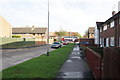
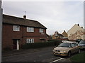
1
A path leading to Tamar Grove, Longhill Estate
Image: © Ian S
Taken: 19 Nov 2012
0.03 miles
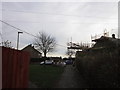
2

A path leading to Tamar Grove, Longhill Estate
Image: © Ian S
Taken: 19 Nov 2012
0.03 miles
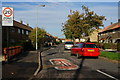
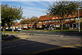

7

Looking across Shannon Road to Wansbeck Road
Longhill Estate, Hull.
Image: © Ian S
Taken: 1 Nov 2013
0.06 miles
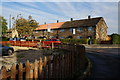
9
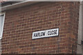
Harlow Close off Hodder Grove, Hull
https://www.geograph.org.uk/photo/6761734
Image: © Ian S
Taken: 21 Feb 2021
0.07 miles