IMAGES TAKEN NEAR TO
Garrick Close, HULL, HU8 0SS
Introduction
This page details the photographs taken nearby to Garrick Close, HU8 0SS by members of the Geograph project.
The Geograph project started in 2005 with the aim of publishing, organising and preserving representative images for every square kilometre of Great Britain, Ireland and the Isle of Man.

There are currently over 7.5m images from over14,400 individuals and you can help contribute to the project by visiting https://www.geograph.org.uk
Image Map
Images are licensed for reuse under creativecommons.org/licenses/by-sa/2.0
Notes
- Clicking on the map will re-center to the selected point.
- The higher the marker number, the further away the image location is from the centre of the postcode.
Image Listing (278 Images Found)
Images are licensed for reuse under creativecommons.org/licenses/by-sa/2.0
Image
Details
Distance
1
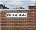
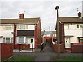
Fortune Close off Bellfield Avenue, Hull
https://www.geograph.org.uk/photo/6826464
Image: © Ian S
Taken: 30 Apr 2021
0.04 miles
3
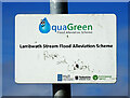
Lambwath Stream Aquagreen, Kingston upon Hull
Lambwath Stream aquagreen, built 2016-17, is located within Ings Recreation Ground (between Bellfield Avenue and Ings Road) as per this plan: https://www.hull.gov.uk/downloads/file/618/Lambwath_stream_scheme.pdf This plot of land was, by 1928, a brick works, with the then Lambwath Stream as its northern boundary. This notice is affixed to a lamp-post abutting the footpath running parallel with the swale. It is affixed above sight-level so easily missed; I only became aware of its existence on my umpteenth visit.
Image: © Bernard Sharp
Taken: 19 Mar 2024
0.05 miles
4
Fortune Close off Bellfield Avenue, Hull
https://www.geograph.org.uk/photo/6826459
Image: © Ian S
Taken: 30 Apr 2021
0.05 miles
6
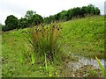
Lambwath Stream Aquagreen, Kingston upon Hull
Lambwath Stream aquagreen, built 2016-17, is located within Ings Recreation Ground (between Bellfield Avenue and Ings Road) as per this plan: https://www.hull.gov.uk/downloads/file/618/Lambwath_stream_scheme.pdf This plot of land was, by 1928, a brick works, with the then Lambwath Stream as its northern boundary. Depicted is one of several clumps of Compact Rush (Juncus conglomeratus) growing in the swale.
Image: © Bernard Sharp
Taken: 14 Jun 2024
0.06 miles
7
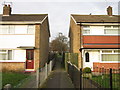
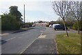
A path leading to Ings Recreation Ground, Hull
Image: © Ian S
Taken: 8 Jan 2013
0.06 miles
8
Lambwath Stream Aquagreen, Kingston upon Hull
Lambwath Stream aquagreen, built 2016-17, is located within Ings Recreation Ground (between Bellfield Avenue and Ings Road) as per this plan: https://www.hull.gov.uk/downloads/file/618/Lambwath_stream_scheme.pdf This plot of land was, by 1928, a brick works, with the then Lambwath Stream as its northern boundary. Depicted are several clumps of Compact Rush (Juncus conglomeratus) growing in the swale. In the background is Bayswater Court.
Image: © Bernard Sharp
Taken: 14 Jun 2024
0.06 miles
9
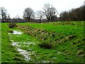
Lambwath Stream Aquagreen, Kingston upon Hull
Lambwath Stream aquagreen, built 2018-19, is located within Ings Recreation Ground (between Bellfield Avenue and Ings Road) as per this plan: https://www.hull.gov.uk/downloads/file/618/Lambwath_stream_scheme.pdf This plot of land was, by 1928, a brick works, with the then Lambwath Stream as its northern boundary.
Image: © Bernard Sharp
Taken: 20 Feb 2024
0.06 miles
10
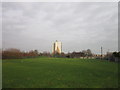
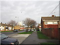
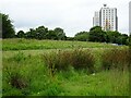
The Ings Recreation Ground, Hull
With the Bayswater Flats in the background.
Image: © Ian S
Taken: 8 Jan 2013
0.06 miles