IMAGES TAKEN NEAR TO
Thorndale, HULL, HU7 6DQ
Introduction
This page details the photographs taken nearby to Thorndale, HU7 6DQ by members of the Geograph project.
The Geograph project started in 2005 with the aim of publishing, organising and preserving representative images for every square kilometre of Great Britain, Ireland and the Isle of Man.

There are currently over 7.5m images from over14,400 individuals and you can help contribute to the project by visiting https://www.geograph.org.uk
Image Map
Images are licensed for reuse under creativecommons.org/licenses/by-sa/2.0
Notes
- Clicking on the map will re-center to the selected point.
- The higher the marker number, the further away the image location is from the centre of the postcode.
Image Listing (44 Images Found)
Images are licensed for reuse under creativecommons.org/licenses/by-sa/2.0
Image
Details
Distance

10

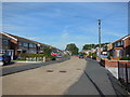
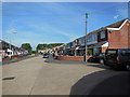
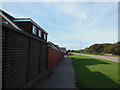
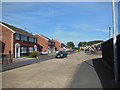
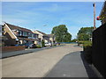
Ennerdale
View east along Ennerdale. The Sutton Park housing estate is to the east of the road with open ground and playing fields to the NW.
Image: © Stephen Horncastle
Taken: 4 Dec 2005
0.09 miles