IMAGES TAKEN NEAR TO
Ferry Road, HULL, HU7 5XU
Introduction
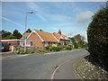
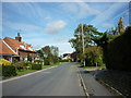
This page details the photographs taken nearby to Ferry Road, HU7 5XU by members of the Geograph project.
The Geograph project started in 2005 with the aim of publishing, organising and preserving representative images for every square kilometre of Great Britain, Ireland and the Isle of Man.

There are currently over 7.5m images from over14,400 individuals and you can help contribute to the project by visiting https://www.geograph.org.uk
Image Map
Images are licensed for reuse under creativecommons.org/licenses/by-sa/2.0
Notes
- Clicking on the map will re-center to the selected point.
- The higher the marker number, the further away the image location is from the centre of the postcode.
Image Listing (75 Images Found)
Images are licensed for reuse under creativecommons.org/licenses/by-sa/2.0
Image
Details
Distance
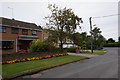
5
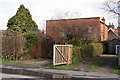
The Methodist Chapel, Wawne
The photograph was taken on Ferry Road, and the access to the chapel was unclear.
Image: © Peter Church
Taken: 12 Mar 2008
0.03 miles
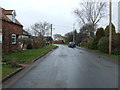
6
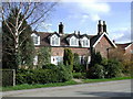
Rose Cottage, Wawne
Cottages just south of the chapel on the east side of Ferry Road, Wawne.
Image: © Paul Glazzard
Taken: 12 Mar 2009
0.03 miles